Texas County Map Printable
Find reviewed sources for texas county map printable, including printable map downloads, format notes, source quality, and licensing cautions.
Curated printable map guide
Texas County Map Printable
Find printable Texas county maps with county boundaries, labels, and reference-friendly layouts. Texas has 254 counties, so a clear county map is useful for school geography, relocation research, regional planning, road-trip context, county-office lookup, and data work.
Counties
254
Texas has more counties than any other U.S. state.
Best map type
Labeled county map
Best for county names and boundary lookup.
Good formats
PDF / PNG
PDF is best for printing; PNG works for quick handouts.
Why this printable map is useful
A Texas county map is useful because the state is large and its county pattern is dense. It helps users compare major metro counties around Houston, Dallas-Fort Worth, Austin, San Antonio, and El Paso with rural counties in West Texas, the Panhandle, South Texas, and the Gulf Coast.
Best pick for most users
U.S. Census Bureau Texas State and County Outline Map
An official outline-style PDF for Texas counties. It is better for formal boundary reference and data-related work than decorative map images.
View best sourceRecommended Texas map sources
Sources are sorted by likely usefulness, format hints, and source type. The strongest options usually match the page intent, use a print-friendly layout, and make the key labels easy to read.
U.S. Census Bureau Texas State and County Outline Map
census.gov
An official outline-style PDF for Texas counties. It is better for formal boundary reference and data-related work than decorative map images.
TxDOT Maps
txdot.gov
TxDOT map resources are useful when county boundaries need to be understood together with highways, transportation regions, or travel planning.
Texas Association of Counties County Information
county.org
A useful starting point when a county map is part of civic, legal, government, or relocation research. It adds county-government context beyond a simple printable image.
More map sources
 Source preview
Texas Counties - Wikipedia
en.wikipedia.org
A practical open-reference page for checking county names, county seats, and basic county information. Use it as a verification aid rather than the only printable map source.
 Source preview
Texas County Map - GISGeography
gisgeography.com
A clear labeled Texas county map that works well for quick reference. Texas has many small and medium-size counties, so this type of map is useful when the main need is to see names and boundaries at a glance.
 Source preview
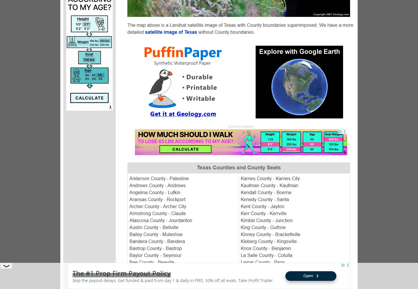
Geology.com Texas County Map
geology.com
A straightforward county-name map with less visual clutter than road-heavy maps. It is useful for worksheets, basic research, or comparing county positions across west, central, north, south, and coastal Texas.
MapChart Texas County Map
mapchart.net
A useful tool when you want to color Texas counties yourself and export a simple custom map for a presentation or worksheet.
Texas map types to look for
Labeled Texas county map
Best for quick reference because all county names are visible on one statewide map.
Blank Texas county map
Useful for quizzes, classroom exercises, and custom color-coding.
Texas county map with cities
Helpful when county boundaries need to be matched with major cities and metro areas.
Official boundary source
Better for data, civic, or planning work where accuracy matters.
Quick comparison
| Source | Map type | Formats | Best for |
|---|---|---|---|
| U.S. Census Bureau Texas State and County Outline Map | state and county outline map | official boundaries, printing | |
| TxDOT Maps | Texas transportation map resources | Web, PDF | road context, state planning |
| Texas Association of Counties County Information | Texas county reference | Web | county government context, official reference |
| Texas Counties - Wikipedia | county list and reference map | Web, Image | county list, verification |
| Texas County Map - GISGeography | labeled Texas county map | Web, Image | quick county lookup, classroom handouts |
| Geology.com Texas County Map | Texas county map with labels | Web, Image | county names, simple printing |
| MapChart Texas County Map | custom county map tool | Web, PNG | custom coloring, presentations |
How to choose the right county map
Choose a labeled county map if you need a quick Texas-wide reference. Use a blank county map for worksheets or custom region coloring. If the map supports civic, legal, emergency, or data work, prioritize official or Census-style boundary sources. For travel, pair a county map with a TxDOT or road map because county boundaries alone do not show route detail.
Printing tips for Texas maps
- Use landscape orientation because Texas is wide and county labels can be dense.
- For classroom work, keep a labeled map as the answer key and print a blank version for exercises.
- If labels are crowded, use legal-size paper or a PDF source.
- For custom regions, use a coloring tool or editable map instead of a flat JPG.
- Check source terms before using county maps in public or commercial projects.
Source and licensing notes
These cards link to external map resources. Always check the original source before reusing a map in commercial projects, apps, printed products, or public materials. Classroom use, personal printing, and commercial reuse may have different license rules.
Related printable maps
FAQ
How many counties are in Texas?
Texas has 254 counties, the most of any U.S. state. A printable county map is useful because the county network is too dense to remember without a visual reference.
What is the best printable Texas county map for students?
A clean labeled county map is best for reference, while a blank county map works better for quizzes and worksheets.
Should I use a Texas county map or a Texas road map?
Use a county map for boundaries and county names. Use a road map for highways, routes, travel planning, and driving distances.
Can I reuse a Texas county map commercially?
Check the original source and usage terms first. Government, educational, open-reference, and commercial map sites can have different reuse rules.
Related guides
More useful articles from the Map Tools & Printable Maps topic.
- California Road Map Printable
Find reviewed sources for california road map printable, including printable map downloads, format notes, source quality, and licensing cautions.
- Florida County Map Printable
Find reviewed sources for florida county map printable, including printable map downloads, format notes, source quality, and licensing cautions.
- Printable Simple Map of London
Find reviewed sources for printable simple map of london, including printable map downloads, format notes, source quality, and licensing cautions.
- New York City Map Printable
Find reviewed sources for new york city map printable, including printable map downloads, format notes, source quality, and licensing cautions.
- North Carolina Map with Cities and Towns Printable
Find reviewed sources for north carolina map with cities and towns printable, including printable map downloads, format notes, source quality, and licensing cautions.
About MyGpsTools Editorial Team
MyGpsTools publishes practical guides about GPS apps, maps, navigation tools, EXIF photo metadata, satellite imagery, Android Auto, Apple CarPlay, ZIP code maps, and location-based technologies. We focus on clear instructions, practical checks, official documentation, and reader feedback.