Florida County Map Printable
Find reviewed sources for florida county map printable, including printable map downloads, format notes, source quality, and licensing cautions.
Curated printable map guide
Florida County Map Printable
Find printable Florida county maps that help you compare county boundaries, county names, and regional layout across the state. Florida has 67 counties, so a clear county map is useful for classroom worksheets, relocation research, road-trip planning, emergency reference, and quick regional lookup.
Counties
67
Florida is divided into 67 counties.
Best map type
Labeled county map
Best for county names, boundaries, and quick reference.
Good formats
PDF / PNG / SVG
PDF is best for printing; SVG is best for editing.
Why this printable map is useful
A Florida county map is more useful than a simple outline map when you need to understand how the state is organized from the Panhandle to South Florida and the Keys. It helps users compare large metro counties such as Miami-Dade, Broward, Palm Beach, Orange, Hillsborough, and Duval with smaller rural counties in North Florida and the interior of the state.
Best pick for most users
U.S. Census Bureau Florida State and County Outline Map
An official Census Bureau outline-style PDF for Florida state and county boundaries. It is useful when you want a formal printable reference rather than a decorative map, especially for government, education, or data-related work.
View best sourceRecommended Florida map sources
Sources are sorted by likely usefulness, format hints, and source type. The strongest options usually match the page intent, use a print-friendly layout, and make the key labels easy to read.
U.S. Census Bureau Florida State and County Outline Map
census.gov
An official Census Bureau outline-style PDF for Florida state and county boundaries. It is useful when you want a formal printable reference rather than a decorative map, especially for government, education, or data-related work.
FDOT Maps and Data
fdot.gov
FDOT's map and GIS resources are useful when a county map needs transportation context, such as highways, planning regions, or official GIS layers. This is not the simplest classroom handout source, but it is valuable for more serious planning or reference work.
Florida Association of Counties County Map
fl-counties.com
A useful reference from the Florida Association of Counties for understanding Florida's county layout in an official county-government context. It is a better fit for civic, relocation, government, and county-structure lookup than for detailed road navigation.
More map sources
Maps ETC Florida County Maps
fcit.usf.edu
An educational map collection from the Florida Center for Instructional Technology. This is especially useful for teachers and students because the collection is organized for classroom-friendly map use rather than travel planning or commercial map downloads.
 Source preview
Wikipedia List of Counties in Florida
en.wikipedia.org
A convenient open-reference page for checking Florida county names alongside a county map and basic county information. It is useful for verification and quick lookup, but the original map image and its file page should be checked before reuse.
 Source preview
GISGeography Florida County Map
gisgeography.com
A clear Florida county map with county labels, useful when the main goal is quick visual reference rather than GIS-level detail. It works well as a starting point for students, travelers, or anyone who needs to identify counties across the Panhandle, Central Florida, South Florida, and the Keys.
 Source preview
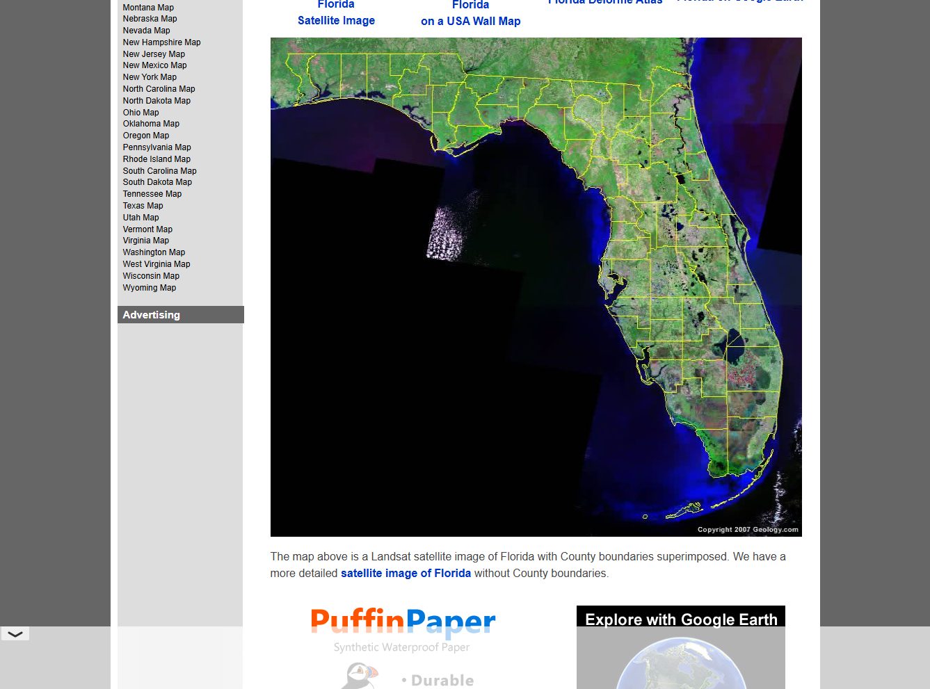
Geology.com Florida County Map
geology.com
A simple labeled county map that is useful when you need county names without extra road or demographic layers. It is a good option for quick reference, classroom discussion, or comparing county positions across northern, central, and southern Florida.
Florida map types to look for
Labeled Florida county map
Best when you need all county names visible on one printable page. This is usually the most useful format for students, teachers, and general reference.
Blank Florida county map
Useful for classroom exercises where students label counties themselves. It is also good for presentations where you want to add your own labels or color coding.
Florida county map with cities
Helpful when county boundaries need to be understood alongside major cities such as Miami, Orlando, Tampa, Jacksonville, Tallahassee, and Fort Lauderdale.
Official or GIS boundary source
Best for more careful work where accuracy matters. These sources may not always be print-friendly, but they are useful for checking boundaries and source data.
Quick comparison
| Source | Map type | Formats | Best for |
|---|---|---|---|
| U.S. Census Bureau Florida State and County Outline Map | state and county outline map | official boundaries, printing | |
| FDOT Maps and Data | Florida transportation and GIS map resources | Web, PDF | official map data, transportation context |
| Florida Association of Counties County Map | Florida county reference map | Web | official county context, county organization |
| Maps ETC Florida County Maps | educational Florida county maps | Web, Image | school use, historical maps |
| Wikipedia List of Counties in Florida | county list and reference map | Web, Image | county list, quick verification |
| GISGeography Florida County Map | labeled Florida county map | Web, Image | quick county lookup, labeled county reference |
| Geology.com Florida County Map | Florida county map with labels | Web, Image | county names, simple reference |
How to choose the right county map
Choose a labeled Florida county map if you need a ready reference with county names. Choose a blank county map if the page is for a classroom worksheet or a custom presentation. If you are planning travel, relocation, or local research, a county map with major cities or highways is usually more helpful than a plain outline. For reuse in a report, app, or commercial product, prefer official or clearly licensed sources and check the original terms before publishing.
Printing tips for Florida maps
- Use landscape orientation if county labels are small or crowded around South Florida and the Panhandle.
- For classroom worksheets, print a blank county map and keep a labeled version as the answer key.
- If the map includes the Florida Keys, preview the page before printing so Monroe County is not cropped.
- Use PDF when available for clean labels and sharper county boundaries.
- For presentations or custom coloring, look for SVG or editable map files instead of a flat JPG.
Source and licensing notes
These cards link to external map resources. Always check the original source before reusing a map in commercial projects, apps, printed products, or public materials. Classroom use, personal printing, and commercial reuse may have different license rules.
Related printable maps
FAQ
How many counties are in Florida?
Florida has 67 counties. A printable county map is useful when you need to see county boundaries, county names, and the layout of the Panhandle, Central Florida, South Florida, and the Keys on one page.
What is the best printable Florida county map for classroom use?
For classroom use, start with a labeled county map for reference and a blank county map for student exercises. A PDF usually prints better than a screenshot because county names and boundary lines stay sharper.
Should I use a Florida county map or a Florida road map?
Use a county map when the main task is identifying counties and county boundaries. Use a road map when you need highways, driving routes, exits, and travel distances. Some sources combine both, but county labels may become harder to read.
Can I reuse these Florida county maps in my own project?
Do not assume reuse is allowed just because a map is easy to download. Check the original source, license, and attribution requirements before using a map in a commercial product, public website, printed guide, or app.
Related guides
More useful articles from the Map Tools & Printable Maps topic.
- California Road Map Printable
Find reviewed sources for california road map printable, including printable map downloads, format notes, source quality, and licensing cautions.
- Printable Simple Map of London
Find reviewed sources for printable simple map of london, including printable map downloads, format notes, source quality, and licensing cautions.
- New York City Map Printable
Find reviewed sources for new york city map printable, including printable map downloads, format notes, source quality, and licensing cautions.
- North Carolina Map with Cities and Towns Printable
Find reviewed sources for north carolina map with cities and towns printable, including printable map downloads, format notes, source quality, and licensing cautions.
- Printable Map of Nova Scotia
Find reviewed sources for printable map of nova scotia, including printable map downloads, format notes, source quality, and licensing cautions.
About MyGpsTools Editorial Team
MyGpsTools publishes practical guides about GPS apps, maps, navigation tools, EXIF photo metadata, satellite imagery, Android Auto, Apple CarPlay, ZIP code maps, and location-based technologies. We focus on clear instructions, practical checks, official documentation, and reader feedback.