Printable Map of Nova Scotia
Find reviewed sources for printable map of nova scotia, including printable map downloads, format notes, source quality, and licensing cautions.
Curated printable map guide
Printable Map of Nova Scotia
Find printable maps of Nova Scotia for travel planning, classroom geography, road reference, and regional orientation. A useful Nova Scotia map should make it easy to understand Halifax, Cape Breton, the Bay of Fundy, the South Shore, the Annapolis Valley, and ferry or highway connections.
Capital
Halifax
A key anchor point on most Nova Scotia maps.
Best map type
Road + regional
Best for travel planning.
Good formats
PDF / Web
Official road maps are often print-friendly.
Why this printable map is useful
Nova Scotia maps are useful because the province has a long coastline, peninsulas, islands, ferry routes, and distinct travel regions. A printable map helps users understand the relationship between Halifax, Cape Breton, coastal towns, the Annapolis Valley, and the Bay of Fundy.
Best pick for most users
Nova Scotia Road Map
An official provincial road-map source and a strong starting point for printable Nova Scotia travel and highway context.
View best sourceRecommended Nova Scotia map sources
Sources are sorted by likely usefulness, format hints, and source type. The strongest options usually match the page intent, use a print-friendly layout, and make the key labels easy to read.
Nova Scotia Road Map
novascotia.ca
An official provincial road-map source and a strong starting point for printable Nova Scotia travel and highway context.
 Source preview
Government of Nova Scotia Open Data
data.novascotia.ca
Useful when you need official provincial data or boundary context rather than a simple travel printout.
Natural Resources Canada - The Atlas of Canada
natural-resources.canada.ca
A useful official Canada-level source when broader geographic or atlas-style context is needed.
More map sources
 Source preview
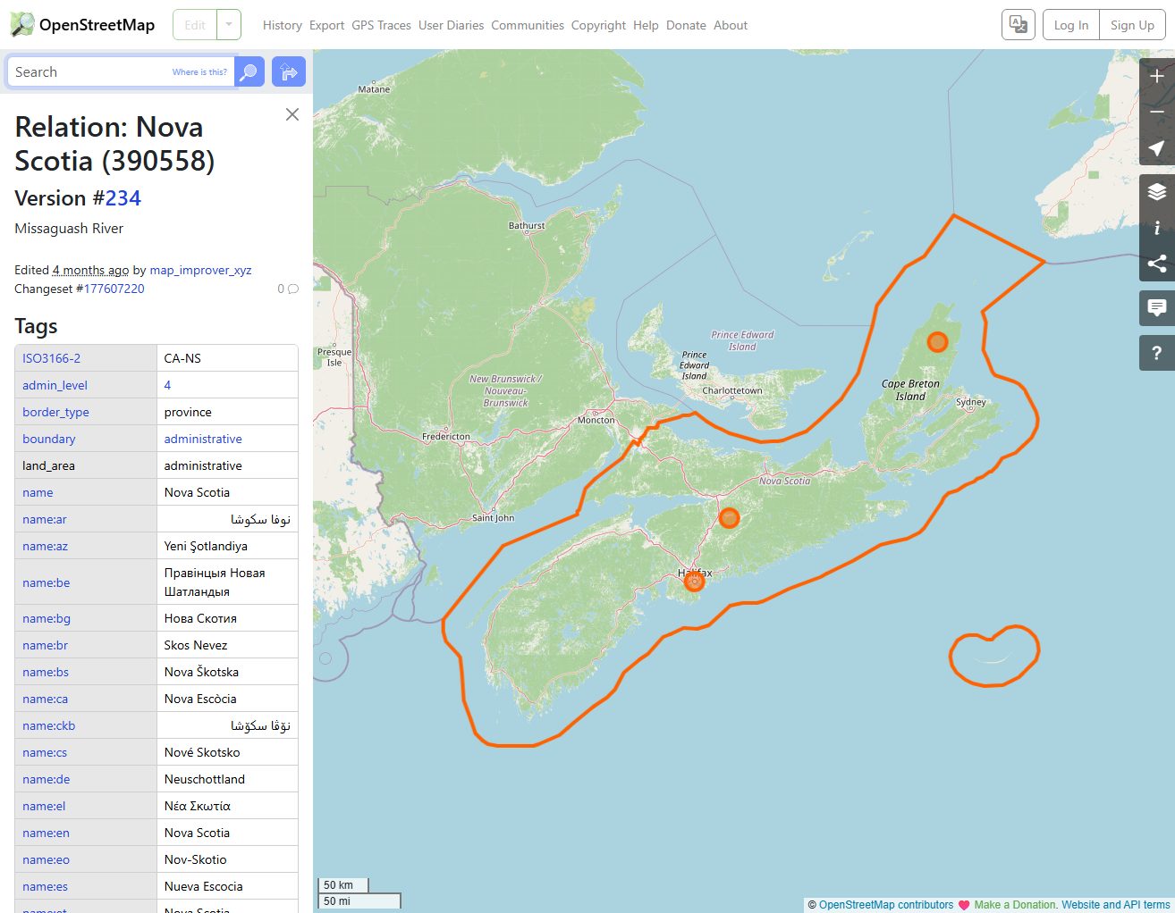
OpenStreetMap Nova Scotia
openstreetmap.org
OpenStreetMap is useful for creating custom views and checking local roads, towns, and regional details.
Nova Scotia - Wikipedia
en.wikipedia.org
A general reference page for province context, major communities, geography, and map images.
Nova Scotia Tourism Maps
novascotia.com
A visitor-focused source that helps connect the map with tourism regions, routes, and trip planning.
 Source preview
Nova Scotia Map - GISGeography
gisgeography.com
A clear province map resource useful for classroom reference and quick orientation.
Nova Scotia map types to look for
Nova Scotia road map
Best for routes, highways, ferry context, and trip planning.
Nova Scotia outline map
Good for classroom labeling or simple province reference.
Tourism region map
Useful for visitors planning coastal routes and attractions.
Official data map
Best for boundaries, research, or formal planning context.
Quick comparison
| Source | Map type | Formats | Best for |
|---|---|---|---|
| Nova Scotia Road Map | official Nova Scotia road map | Web, PDF | official road reference, travel planning |
| Government of Nova Scotia Open Data | Nova Scotia data and map resources | Web | official data, boundaries |
| Natural Resources Canada - The Atlas of Canada | Canadian atlas maps | Web | national reference, official context |
| OpenStreetMap Nova Scotia | editable province map reference | Web | custom map views, road context |
| Nova Scotia - Wikipedia | province reference map | Web, Image | quick verification, general reference |
| Nova Scotia Tourism Maps | Nova Scotia travel maps | Web | tourism, regional planning |
| Nova Scotia Map - GISGeography | Nova Scotia reference map | Web, Image | quick reference, classroom use |
How to choose the right province map
Choose an official road map for travel and highway planning. Choose a tourism map when attractions and regions matter. For classroom use, use a simpler outline or labeled province map. For data or boundary work, use government open data or atlas resources.
Printing tips for Nova Scotia maps
- Use landscape orientation to fit the province shape and coastline better.
- For road trips, choose a map that includes highways and ferry routes.
- For classroom use, avoid overly detailed road maps.
- Check whether Cape Breton and the South Shore remain readable when printed small.
- Use official sources if the map supports travel or planning decisions.
Source and licensing notes
These cards link to external map resources. Always check the original source before reusing a map in commercial projects, apps, printed products, or public materials. Classroom use, personal printing, and commercial reuse may have different license rules.
Related printable maps
FAQ
What should a printable Nova Scotia map include?
A useful printable map should include Halifax, major highways, Cape Breton, the Bay of Fundy, the South Shore, and key regional labels.
Is a tourism map or road map better?
Use a tourism map for attractions and regions. Use a road map for driving routes, highways, ferry planning, and distances.
What format is best for printing?
PDF is usually best because labels and roads stay sharp. Web images work for quick reference but may blur when enlarged.
Can I reuse Nova Scotia map images commercially?
Check the original source and license before reuse. Government, tourism, open data, and third-party map sites may have different terms.
Related guides
More useful articles from the Map Tools & Printable Maps topic.
- California Road Map Printable
Find reviewed sources for california road map printable, including printable map downloads, format notes, source quality, and licensing cautions.
- Florida County Map Printable
Find reviewed sources for florida county map printable, including printable map downloads, format notes, source quality, and licensing cautions.
- Printable Simple Map of London
Find reviewed sources for printable simple map of london, including printable map downloads, format notes, source quality, and licensing cautions.
- New York City Map Printable
Find reviewed sources for new york city map printable, including printable map downloads, format notes, source quality, and licensing cautions.
- North Carolina Map with Cities and Towns Printable
Find reviewed sources for north carolina map with cities and towns printable, including printable map downloads, format notes, source quality, and licensing cautions.
About MyGpsTools Editorial Team
MyGpsTools publishes practical guides about GPS apps, maps, navigation tools, EXIF photo metadata, satellite imagery, Android Auto, Apple CarPlay, ZIP code maps, and location-based technologies. We focus on clear instructions, practical checks, official documentation, and reader feedback.