Oregon Map with Cities Printable
Find reviewed sources for oregon map with cities printable, including printable map downloads, format notes, source quality, and licensing cautions.
Curated printable map guide
Oregon Map with Cities Printable
Find printable Oregon maps with cities, major roads, and state reference context. This type of map is useful for travel planning, classroom geography, relocation research, and understanding where Portland, Salem, Eugene, Bend, Medford, and coastal cities sit within the state.
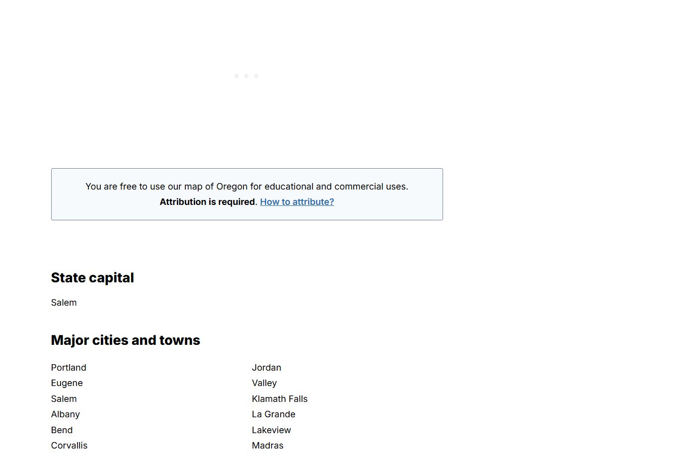
Capital
Salem
Useful anchor point on most Oregon city maps.
Best map type
Cities + highways
Best for travel and orientation.
Good formats
PDF / PNG
PDF is best for clean printing.
Why this printable map is useful
An Oregon map with cities is helpful because the state combines the Willamette Valley, the coast, the Cascades, Central Oregon, and large rural eastern regions. A simple city map helps users quickly understand the relationship between Portland, Salem, Eugene, Bend, Medford, and smaller towns.
Best pick for most users
Oregon Department of Transportation Maps and Data
ODOT maps are useful when printable city reference needs highway, route, or transportation context.
View best sourceRecommended Oregon map sources
Sources are sorted by likely usefulness, format hints, and source type. The strongest options usually match the page intent, use a print-friendly layout, and make the key labels easy to read.
 Source preview
Oregon Department of Transportation Maps and Data
oregon.gov
ODOT maps are useful when printable city reference needs highway, route, or transportation context.
Oregon Geospatial Enterprise Office
oregon.gov
A better source for users who need official Oregon geospatial context rather than a simple classroom printout.
Oregon - OpenStreetMap
openstreetmap.org
OpenStreetMap is useful for creating or checking custom map views, especially when you need city and road context rather than a static image.
More map sources
Oregon - Wikipedia
en.wikipedia.org
A quick open-reference page for checking Oregon geography, major cities, and general state context alongside map images.
 Source preview
Oregon Map - GISGeography
gisgeography.com
A clear Oregon map resource that shows the state layout and key places without overwhelming detail. Useful for quick city reference and general geography.
 Source preview
Geology.com Oregon Cities Map
geology.com
A simple cities map that is useful when the main task is locating Oregon cities rather than reading a full road atlas.
Travel Oregon Maps
traveloregon.com
Useful for trip planning and visitor-friendly context, especially when city locations need to be understood with regions and travel routes.
Oregon map types to look for
Oregon map with cities
Best for locating major cities and towns quickly.
Oregon road map
Better for driving routes, highways, and trip planning.
Blank Oregon outline map
Useful for classroom labeling and custom notes.
Official GIS or ODOT map
Best for accurate planning, transportation, or data work.
Quick comparison
| Source | Map type | Formats | Best for |
|---|---|---|---|
| Oregon Department of Transportation Maps and Data | Oregon transportation maps | Web, PDF | official maps, road context |
| Oregon Geospatial Enterprise Office | Oregon geospatial map resources | Web | official GIS data, boundary context |
| Oregon - OpenStreetMap | editable Oregon map reference | Web | open map data, custom map views |
| Oregon - Wikipedia | state reference map | Web, Image | quick verification, general reference |
| Oregon Map - GISGeography | Oregon map with cities | Web, Image | city lookup, classroom reference |
| Geology.com Oregon Cities Map | Oregon cities map | Web, Image | city names, simple reference |
| Travel Oregon Maps | Oregon travel maps | Web | travel planning, visitor context |
How to choose the right map with cities
Choose a city map if the main goal is locating Oregon cities and towns. Choose a road map if driving routes, highways, or trip planning matter. For classroom use, a simple labeled or blank map is often better than a dense transportation map. For official planning, use Oregon government map resources.
Printing tips for Oregon maps
- Use landscape orientation if the map includes both the coast and eastern Oregon.
- For travel planning, choose a map that includes highways as well as city names.
- For classroom use, avoid maps with too many local roads.
- PDF sources usually keep labels sharper than screenshots.
- Check whether Portland-area labels remain readable before printing on letter-size paper.
Source and licensing notes
These cards link to external map resources. Always check the original source before reusing a map in commercial projects, apps, printed products, or public materials. Classroom use, personal printing, and commercial reuse may have different license rules.
Related printable maps
FAQ
What should a printable Oregon city map include?
A useful Oregon city map should show major cities such as Portland, Salem, Eugene, Bend, Medford, and coastal or eastern Oregon reference points.
Is a city map better than an Oregon road map?
Use a city map for orientation and quick lookup. Use a road map when you need highways, routes, distances, and driving context.
What format is best for printing an Oregon map?
PDF is usually best for sharp labels and clean boundaries. PNG or JPG can work for quick handouts but may blur when enlarged.
Can I use an Oregon map for a presentation?
Yes, but check the source license first. If you need to edit labels or colors, look for SVG, open data, or a map-creation tool.
Related guides
More useful articles from the Map Tools & Printable Maps topic.
- California Road Map Printable
Find reviewed sources for california road map printable, including printable map downloads, format notes, source quality, and licensing cautions.
- Florida County Map Printable
Find reviewed sources for florida county map printable, including printable map downloads, format notes, source quality, and licensing cautions.
- Printable Simple Map of London
Find reviewed sources for printable simple map of london, including printable map downloads, format notes, source quality, and licensing cautions.
- New York City Map Printable
Find reviewed sources for new york city map printable, including printable map downloads, format notes, source quality, and licensing cautions.
- North Carolina Map with Cities and Towns Printable
Find reviewed sources for north carolina map with cities and towns printable, including printable map downloads, format notes, source quality, and licensing cautions.
About MyGpsTools Editorial Team
MyGpsTools publishes practical guides about GPS apps, maps, navigation tools, EXIF photo metadata, satellite imagery, Android Auto, Apple CarPlay, ZIP code maps, and location-based technologies. We focus on clear instructions, practical checks, official documentation, and reader feedback.