Ohio County Map Printable
Find reviewed sources for ohio county map printable, including printable map downloads, format notes, source quality, and licensing cautions.
Curated printable map guide
Ohio County Map Printable
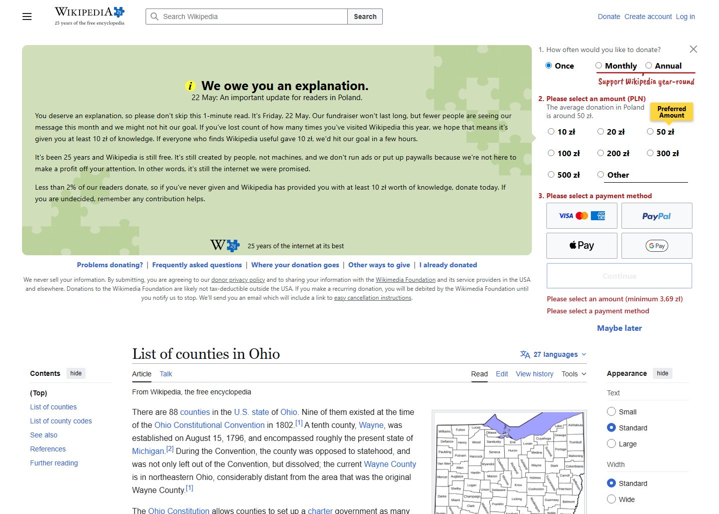
Find printable Ohio county maps with labels, boundary outlines, and print-friendly sources. Ohio has 88 counties, so a clear county map is useful for school geography, relocation research, regional planning, local government lookup, and quick reference.
Counties
88
Ohio is divided into 88 counties.
Best map type
Labeled county map
Best for county names and quick lookup.
Good formats
PDF / PNG
PDF usually prints cleaner than screenshots.
Why this printable map is useful
An Ohio county map is useful for understanding the state beyond major cities such as Columbus, Cleveland, Cincinnati, Toledo, Akron, and Dayton. It helps compare metro counties with rural and Appalachian counties in eastern and southern Ohio.
Best pick for most users
U.S. Census Bureau Ohio State and County Outline Map
An official Census outline-style PDF for Ohio counties. Use it when a cleaner formal boundary reference is more important than decoration.
View best sourceRecommended Ohio map sources
Sources are sorted by likely usefulness, format hints, and source type. The strongest options usually match the page intent, use a print-friendly layout, and make the key labels easy to read.
U.S. Census Bureau Ohio State and County Outline Map
census.gov
An official Census outline-style PDF for Ohio counties. Use it when a cleaner formal boundary reference is more important than decoration.
Ohio Department of Transportation Maps
transportation.ohio.gov
ODOT map resources are useful when county boundaries need to be understood alongside highways, routes, and state transportation context.
County Commissioners Association of Ohio
ccao.org
A useful county-government reference for Ohio county names, county seats, and local context. It complements printable maps with civic information.
More map sources
 Source preview
Ohio Counties - Wikipedia
en.wikipedia.org
A convenient open-reference page for checking Ohio county names, county seats, and background details alongside a map.
Ohio County Map - GISGeography
gisgeography.com
A clear labeled Ohio county map that is useful for quick reference and classroom work. It helps users locate counties across northern, central, southern, and Appalachian Ohio without extra road-map clutter.
 Source preview
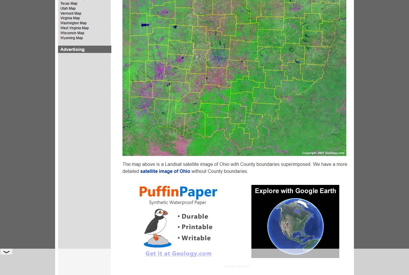
Geology.com Ohio County Map
geology.com
A simple labeled county map that works well when you only need county names and boundaries. It is a practical option for quick lookup or basic worksheets.
 Source preview
MapChart Ohio County Map
mapchart.net
Useful when you need to create a custom colored Ohio county map for a worksheet, presentation, or regional grouping.
Ohio map types to look for
Labeled Ohio county map
Best for general reference and classroom use.
Blank Ohio county map
Useful for quizzes and custom labeling.
Ohio county map with cities
Helpful when county boundaries need context from major cities.
Official outline map
Better for formal reference, reports, or data work.
Quick comparison
| Source | Map type | Formats | Best for |
|---|---|---|---|
| U.S. Census Bureau Ohio State and County Outline Map | state and county outline map | official boundaries, printing | |
| Ohio Department of Transportation Maps | Ohio transportation and map resources | Web, PDF | official maps, road context |
| County Commissioners Association of Ohio | Ohio county information | Web | county government context, county list |
| Ohio Counties - Wikipedia | county list and reference map | Web, Image | verification, county list |
| Ohio County Map - GISGeography | labeled Ohio county map | Web, Image | quick county lookup, classroom reference |
| Geology.com Ohio County Map | Ohio county map with labels | Web, Image | county names, simple reference |
| MapChart Ohio County Map | custom county map tool | Web, PNG | custom coloring, presentations |
How to choose the right county map
Use a labeled Ohio county map for quick county-name reference. Use a blank outline map for worksheets or custom coloring. If you need road context, choose an ODOT or transportation map. For reports or data work, use Census or government-style boundary sources.
Printing tips for Ohio maps
- Landscape orientation usually works well for a statewide Ohio county map.
- Use PDF sources when county labels need to stay sharp.
- For school worksheets, print a blank map and keep a labeled one as the answer key.
- Avoid road-heavy maps when the task is county identification only.
- Check original source terms before reuse.
Source and licensing notes
These cards link to external map resources. Always check the original source before reusing a map in commercial projects, apps, printed products, or public materials. Classroom use, personal printing, and commercial reuse may have different license rules.
Related printable maps
FAQ
How many counties are in Ohio?
Ohio has 88 counties. A printable county map is useful for seeing all county boundaries and names in one view.
What Ohio county map is best for classroom use?
A simple labeled county map is best for reference, while a blank county map is better for student labeling exercises.
Do I need a county map or a road map of Ohio?
Use a county map for county boundaries and names. Use a road map for highways, routes, and driving context.
Can I edit a printable Ohio county map?
If you need to edit colors or labels, choose an SVG, vector, or interactive map tool rather than a flat image.
Related guides
More useful articles from the Map Tools & Printable Maps topic.
- California Road Map Printable
Find reviewed sources for california road map printable, including printable map downloads, format notes, source quality, and licensing cautions.
- Florida County Map Printable
Find reviewed sources for florida county map printable, including printable map downloads, format notes, source quality, and licensing cautions.
- Printable Simple Map of London
Find reviewed sources for printable simple map of london, including printable map downloads, format notes, source quality, and licensing cautions.
- New York City Map Printable
Find reviewed sources for new york city map printable, including printable map downloads, format notes, source quality, and licensing cautions.
- North Carolina Map with Cities and Towns Printable
Find reviewed sources for north carolina map with cities and towns printable, including printable map downloads, format notes, source quality, and licensing cautions.
About MyGpsTools Editorial Team
MyGpsTools publishes practical guides about GPS apps, maps, navigation tools, EXIF photo metadata, satellite imagery, Android Auto, Apple CarPlay, ZIP code maps, and location-based technologies. We focus on clear instructions, practical checks, official documentation, and reader feedback.