Top 10 Crypto with Lowest Transaction Fees: Your Complete Guide to Fee-Efficient Digital Assets
Cheapest crypto to transfer in 2026. Compare transaction fees, speeds, and find the best low-fee cryptocurrencies for your digital transactions.
GPS, maps and location tools
MyGpsTools helps you understand Google Maps, Waze, satellite imagery, EXIF GPS metadata, ZIP code maps, Android Auto, Apple CarPlay, and everyday navigation problems in simple language.
Quick entry points for the main things people use MyGpsTools for: checking current coordinates, reading photo GPS data, finding ZIP code maps, fixing map apps, and understanding navigation tools.
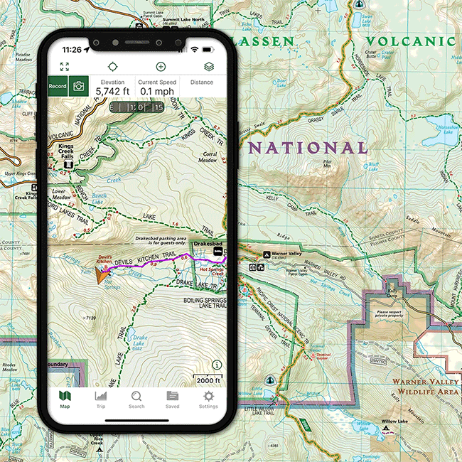
Find your current GPS location, copy latitude and longitude, check accuracy, and open the point in Google Maps, Apple Maps, or Waze.

Upload a photo and check hidden EXIF metadata, GPS coordinates, camera details, and location information.
Find city ZIP code maps, ZIP code lists, nearby areas, GPS coordinates, and local map resources.
Practical guides for Google Maps location sharing, speed limits, offline maps, routes, and troubleshooting.

Learn how to use Waze, fix GPS problems, save mobile data, plan routes, and troubleshoot navigation issues.
Curated topic hubs for maps, GPS coordinates, satellite imagery, navigation apps, car displays, local maps, and mobile troubleshooting.
Speed limits, location sharing, search history, data usage, satellite view, and common fixes.
Offline maps, data usage, satellite mode, voice packs, route errors, and Waze settings.
Google Earth, satellite image updates, real-time satellite view limits, and imagery tools.
GPS coordinates apps, EXIF location extraction, map QR codes, and location tools.
GPS trackers, location sharing, family tracking apps, route tracking, and location privacy settings.
Printable maps, downloadable map resources, state maps, country maps, blank maps, and map tools.
ZIP code maps, city ZIP code lists, GPS coordinates, nearby cities, and local map resources.
GPS apps, offline maps, hiking apps, driving apps, and navigation comparisons.
Data usage, offline maps, connection errors, car compatibility, volume issues, and fixes.
Connection issues, audio problems, GPS accuracy, YouTube, music apps, and car-specific fixes.
Phone, app, and mobile troubleshooting guides related to navigation and mobile tools.
Running apps, walking distance trackers, pedometers, and outdoor GPS apps.
GPS speedometer apps, online speed tests, boat speed tracking, MPH and KPH tools.
Visited countries maps, travel trackers, state counters, and trip mapping apps.
Recent guides, tutorials, app reviews, troubleshooting notes, and map-related resources.
Cheapest crypto to transfer in 2026. Compare transaction fees, speeds, and find the best low-fee cryptocurrencies for your digital transactions.
Search 74 Austin, Texas ZIP codes by local area, Travis County postal place, coordinates, and map direction. Includes printable maps for North, South, East, and West Austin.

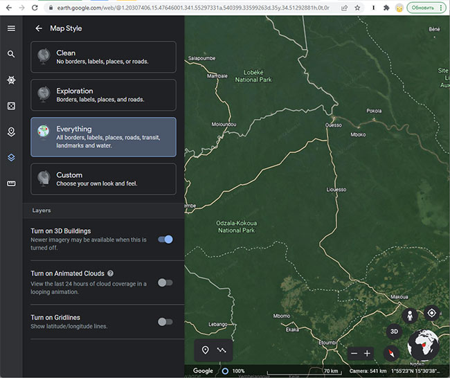
Compare free and paid satellite imagery platforms in 2026. Learn the differences between Google Earth, Maxar, Airbus, Sentinel Hub, and USGS EarthExplorer. Find out which service offers the resolution, update frequency, and features you actually need.
Search 45 Columbus, Ohio ZIP codes by local area, Franklin County postal place, ZIP type, or coordinates. Includes printable maps for North, South, East, and West Columbus.
Search 137 El Paso ZIP codes by local area, El Paso County postal place, coordinates, and map direction. Includes printable maps for North, South, East, and West El Paso.
Search 47 Fort Lauderdale ZIP codes by local area, Broward County postal place, coordinates, and map direction. Includes printable maps for North, South, East, and West Fort Lauderdale.
Search 58 Fresno ZIP codes by local area, Fresno County postal place, coordinates, and map direction. Includes printable maps for North, South, East, and West Fresno.
Learn how often Google Earth imagery updates, why image age varies by city or region, how to check the capture date, and when to use more current satellite imagery tools.
Search 178 Houston ZIP codes by local area, Harris County postal place, or coordinates. Includes printable maps for North, South, East, and West Houston.
Search 41 Milwaukee ZIP codes by local area, Milwaukee County postal place, coordinates, and map direction. Includes printable maps for North, South, East, and West Milwaukee.
Search 69 Minneapolis ZIP codes by local area, Hennepin County postal place, coordinates, and map direction. Includes printable maps for North, South, East, and West Minneapolis.
Search 87 Philadelphia ZIP codes by neighborhood, Philadelphia County area, coordinates, and map direction. Includes printable maps for North, South, East, and West Philadelphia.
Search 75 Pittsburgh ZIP codes by local area, Allegheny County postal place, coordinates, and map direction. Includes printable maps for North, South, East, and West Pittsburgh.
Learn what live satellite view really means in 2026, which tools show recent or near-real-time imagery, and why true live views of a house are not available to regular users.
Search 52 Salt Lake City ZIP codes by local area, Salt Lake County postal place, coordinates, and map direction. Includes printable maps for North, South, East, and West Salt Lake City.