How Often Does Google Maps Update Satellite Images and Data
How to find out the specific date of photo. You can check satellite image date. All open spaces on our planet are already captured on Google Maps or Earth
Table of contents
Google Maps satellite images update on varying schedules depending on location population and geographic importance. Urban areas refresh more frequently than rural regions, with some locations receiving new aerial photography every few months while others may wait years between updates.
Google Maps Update Frequency: What You Need to Know
Understanding how often Google Maps updates its satellite imagery is crucial for users who rely on current geographic data. The update schedule varies significantly based on several factors that determine refresh frequency.
Related Google Maps and Google Earth Guides
- How often are Google Maps updated?
- Google Maps speed limits explained
- Google Maps location sharing issues
- How to fix Google Earth running slow
- Best satellite imagery tools
- Real-time satellite view: what is actually possible?
How Often Does Google Maps Update Satellite Images?
Google Maps satellite images are updated based on:
- Population density: Urban areas with higher population receive more frequent updates
- Geographic importance: Major cities and commercial areas get priority refresh schedules
- Data availability: New aerial photography from satellite providers determines update timing
- Location demand: Frequently viewed areas may receive more regular imagery updates
Most urban locations see satellite image updates every 1-3 years, while rural areas may experience longer intervals between refreshes.
When Does Google Maps Update Pictures?
Google updates maps pictures through a continuous process rather than on fixed schedules. The frequency depends on:
- Satellite data acquisition: New imagery from satellite providers
- Aerial photography campaigns: Scheduled flights for high-resolution pictures
- Image processing time: Data verification and quality control procedures
- Geographic prioritization: Urban areas receive updates more frequently
How to Check When Google Maps Was Last Updated
To determine the exact date of satellite images in your area:
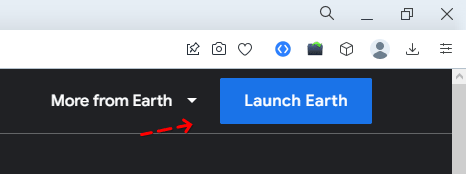
For Google Maps Desktop:
Step 1. Go to maps.google.com
Step 2. Specify the street and, if necessary, the house number in the search box

Step 3. Move the yellow icon (Pegman) to the area for which you want to activate street view.
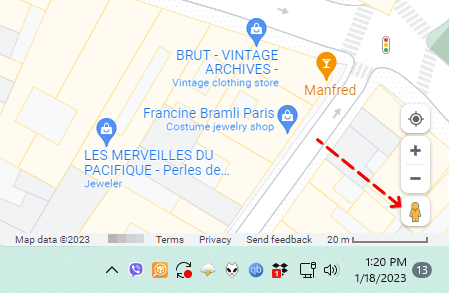
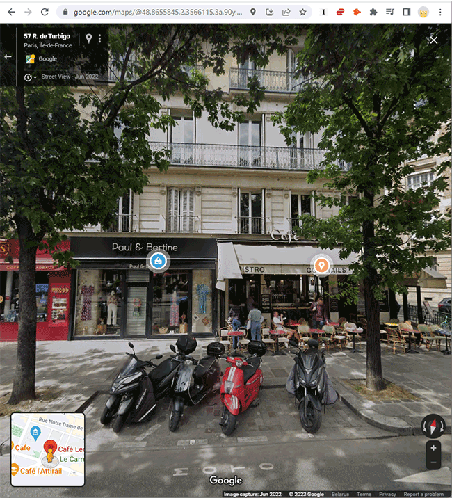
Step 4. Image capture time will be indicated (the same as in the case of Google Earth) in the status bar.
Step 5. Note, however, that Street View does not show the exact time of capture, but only the month and year. That's not a bad thing in most cases.
For Google Maps Mobile:
- Zoom in on the area of interest
- Tap and hold on the map to reveal date information
- Look at bottom right of screen for capture date
- Zoom further if date doesn't appear initially
For Google Earth (Most Detailed):
Step 1. Download the program Google Earth, if necessary. There are versions for PC and Mac OS. But the web version is best.
Step 2. Through the search, find the city, street and house, for a reference point.
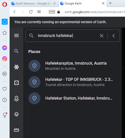
Step 3. The larger the object, the greater the chance of knowing the specific date. Therefore, it is advisable to zoom in on the area on the map at the maximum scale.
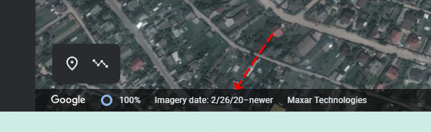
Step 4. Put the mouse cursor on the map and look in the status bar.
Step 5. In the status bar will be available information about the date of creation of the image (Imagery date field).
Step 6. If no date is specified, try to perform the same operation with the adjacent parts of the map.
Google Earth Historical Imagery Feature
Google Earth provides the most comprehensive view of satellite image updates through its Historical Imagery feature:
- Time slider functionality: Navigate through years of satellite data
- Multiple date options: View how areas changed over time
- Capture date display: See exact dates when images were taken
- Image comparison: Compare current and historical aerial photography
Why Google Maps Satellite Images Have Different Ages
Several factors explain why satellite imagery varies in age across different locations:
Image Mosaics: Google often combines pictures from different dates to create seamless maps coverage. This means adjacent areas might show imagery captured months apart.
Data Confidence: In some cases, capture dates may not display if Google has low confidence in the date accuracy or if images are part of complex mosaics.
Processing Delays: New satellite data requires processing time before appearing in Google Maps, creating gaps between capture and publication.
Regional Priorities: Popular tourist destinations and major cities receive more frequent aerial photography updates than remote areas.
Street View Update Schedule
Google Street View images follow a different update frequency than satellite imagery:
- Urban areas: Updated every 1-2 years in major cities
- Rural locations: May wait 3-5 years between Street View refreshes
- Popular destinations: Tourist areas receive more frequent updates
- Seasonal variations: Some locations photographed during specific seasons
Finding the Most Recent Google Maps Data
To access the freshest satellite images and aerial photography:
- Use Google Earth Pro: Offers more robust historical imagery features
- Check multiple zoom levels: Different scales may show more recent data
- Compare with Street View: Cross-reference satellite and street-level imagery dates
- Monitor Google Earth Blog: Stay informed about major imagery updates
Factors Affecting Google Maps Update Frequency
Population Density: Areas with more residents and businesses receive priority for satellite image updates.
Economic Activity: Commercial districts and industrial zones get more frequent aerial photography.
Geographic Changes: Locations experiencing rapid development may receive accelerated update schedules.
User Interest: Frequently searched locations may influence refresh priority.
Data Partnerships: Relationships with satellite imagery providers affect update availability.
When Will Google Maps Update My Area?
While Google doesn't publish specific update schedules, you can estimate when your area might receive new satellite imagery:
- Major cities: Expect updates every 1-2 years
- Suburban areas: Updates typically occur every 2-3 years
- Rural locations: May wait 3-5 years between refreshes
- Remote areas: Updates can be sporadic, sometimes 5+ years apart
Tips for Getting the Most Current Google Maps Data
- Use multiple platforms: Compare Google Maps, Google Earth, and Street View for latest imagery
- Check neighboring areas: Adjacent locations might have more recent satellite pictures
- Monitor seasonal patterns: Some regions receive updates during specific months
- Follow Google Earth social media: Stay informed about major imagery releases
Understanding Google Maps update frequency helps users make informed decisions about data currency. While urban areas enjoy regular satellite image refreshes, rural locations may require patience for the latest aerial photography. Using Google Earth's historical imagery feature provides the most comprehensive view of how often your specific area receives updates.
Related guides
More useful articles from the Satellite Imagery & Google Earth topic.
- Best High-Resolution Satellite Imagery
Compare free and paid satellite imagery platforms in 2026. Learn the differences between Google Earth, Maxar, Airbus, Sentinel Hub, and USGS EarthExplorer. Find out which service offers the resolution, update frequency, and features you actually need.
- How Old Is Google Earth Imagery?
Learn how often Google Earth imagery updates, why image age varies by city or region, how to check the capture date, and when to use more current satellite imagery tools.
- Live Satellite View of Your House
Learn what live satellite view really means in 2026, which tools show recent or near-real-time imagery, and why true live views of a house are not available to regular users.
- What Are the Best Google Earth Alternatives? [2026 Guide]
15 powerful Google Earth alternatives for 2026. Expert-reviewed satellite imagery tools, real-time mapping, and GIS solutions for professionals and casual users.
- How to Fix Google Earth Not Working or Won’t Load Issues: Complete Troubleshooting Guide
Practical fixes for Google Earth when it won’t load, keeps crashing, or runs slowly on desktop, web, iPad, and mobile.
About MyGpsTools Editorial Team
MyGpsTools publishes practical guides about GPS apps, maps, navigation tools, EXIF photo metadata, satellite imagery, Android Auto, Apple CarPlay, ZIP code maps, and location-based technologies. We focus on clear instructions, practical checks, official documentation, and reader feedback.