Google Maps shows wrong current location: how to fix on Android and iOS
Fix Google Maps when your current location is wrong on Android or iPhone. Learn what causes GPS errors and what to check in location settings, permissions, Wi-Fi, and calibration.
Google Maps is a popular navigation app used to help people get directions and find locations. However, sometimes Google Maps may show the wrong location on Android and iOS devices. This can be caused by a number of factors, including incorrect GPS settings, an outdated version of the app, poor line of sight to GPS satellites, and more.
Fortunately, there are a few simple steps that users can take to help fix the issue. By following these steps, users can ensure that Google Maps is able to accurately display their location.
Table of contents
Google Maps shows wrong location: main reasons
Incorrect Data on the Map: Google Maps gets its data from third-party sources like government organizations, public institutions, and private companies. If the data is outdated or inaccurate, it can lead to the wrong location being shown in the app.
GPS Signal Interference: GPS signals can be interrupted by tall buildings, mountains, and even weather conditions like rain or fog. This can cause the location to be inaccurate.
Outdated Software: If the Google Maps app on your device is not up to date, it may not be able to accurately pinpoint your location.
Poor Network Connection: If your device is not connected to the internet, or if the connection is slow, it can cause Google Maps to display the wrong location.
Incorrect Location Settings: If your device's location settings are incorrect, it can cause Google Maps to show the wrong location.
Note: To compare a saved image with your current location, check GPS data in a photo and open the coordinates in Google Maps.
GPS signal interference
GPS signal interference can have a significant effect on the accuracy of Google Maps. GPS signals are necessary for Google Maps to accurately determine a user's location and provide them with directions. When GPS signals are interfered with, Google Maps may not be able to determine a user's exact location, and the routes and directions provided may not be accurate. This could lead to a user getting lost, arriving late, or missing their destination altogether.
Here are some steps to prevent GPS signal interference from affecting the accuracy of Google Maps:
Avoid placing metal objects near your device. Metal objects, such as metal shelves and metal furniture, can block or reflect GPS signals and reduce their accuracy. If possible, move these objects away from your device.
Turn off any Bluetooth or Wi-Fi connections on your device. These connections can interfere with GPS signals and reduce their accuracy.
- Make sure that the latest version of Google Maps is installed, as this can help improve GPS accuracy.
If any updates are available, the user will be prompted to install them.
Update Google Maps to improve the accuracy
In order to ensure that Google Maps is running at its most accurate, users should make sure that the device they are using to access the service is running the most up-to-date software. By keeping the deviceРІР‚в„ўs operating system and other software up-to-date, users can ensure that they are getting the most accurate information when using Google Maps.
Another way for users to keep their deviceРІР‚в„ўs software up-to-date is to set the device to automatically check for updates. This can usually be done in the settings menu of the device and will allow the device to check for any available updates on a regular basis.
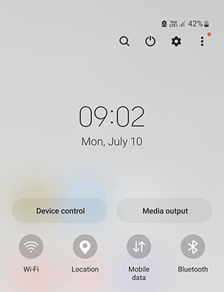
Reset Google Maps app on an Android device
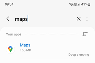
The best way to reset the Google Maps app on an Android device is to uninstall and then reinstall the app. This is a simple process that can be done in a few steps.
Resetting the Google Maps app on an Android device is a simple process. All you need to do is uninstall and then reinstall the app.
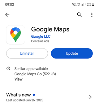
Step 1. First, open the Google Play Store app on your device.

Step 2. Search for “Google Maps” and select it from the search results. On the app page, select “Uninstall”.
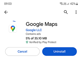
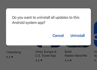
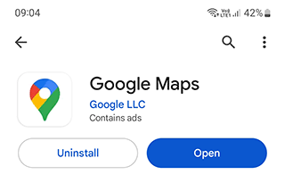
Step 3. You will be prompted to confirm the uninstallation. Tap “Uninstall” again.
The Google Maps app will be removed from your device.
Step 4. Next, open the Google Play Store app again and search for “Google Maps”.
Step 5. Select the app from the search results and select “Install”. You will be prompted to confirm the installation.
Step 6. Select “Ok”. The Google Maps app will be installed on your device.
Step 7. Once the installation is complete, open the app. You will be prompted to sign in to your Google account.
Step 8. Once you have signed in, the app will be reset to its default settings. You can now use the app as normal.
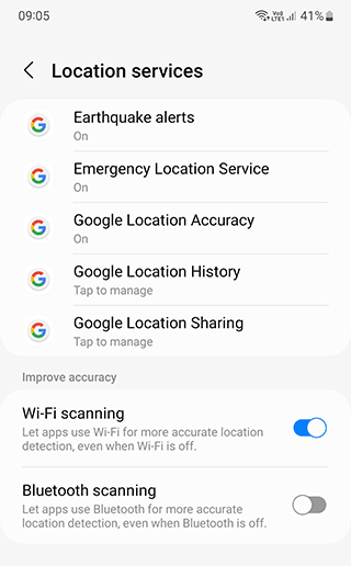
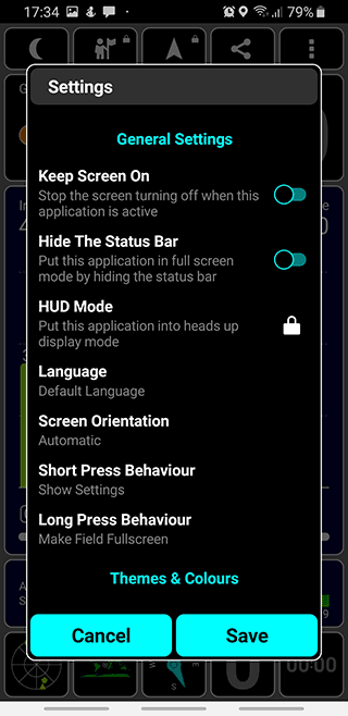
Fix Incorrect Location Settings
Incorrect location settings on Android can be a very frustrating issue. As a result, all applications related to GPS navigation such as Google Maps do not work correctly and display the wrong geolocation.
There are some steps you can take in order to fix this.
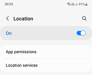
Step 1. Check Your Location Service Settings: The first thing you should do is check your location service settings.
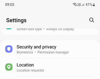
Make sure that the location services are turned on, and that the correct mode (High Accuracy, Device Only, Battery Saving, or Off) is selected. To do this, go to Settings > Location, and make sure that the toggle button is switched to the On position.
Step 2. Check GPS Settings: You should also check to make sure that your GPS settings are enabled. To do this,
Step 3. Go to Settings > Location.
Step 4. Make sure that GPS is enabled for all the services.
 .
.
Step 5. Check Wi-Fi Settings: Another possible cause of incorrect location settings is incorrect Wi-Fi settings. Go to Settings > Wi-Fi, and make sure that the Wi-Fi is turned on and that it is connected to the correct network.
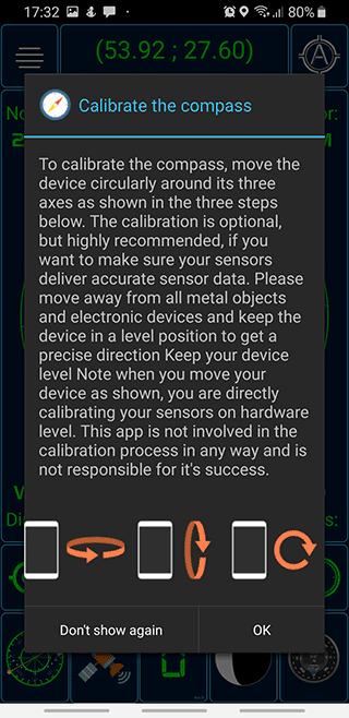
Calibrating GPS in a regular way
Another way to fix an error with the wrong location on Google Maps is to calibrate the GPS sensor on your mobile phone.
You can use your phone's built-in features for calibration. In order to do this:
Go to the engineering menu by dialing
##3646633*#*#. The combinations##4636##or#15963#work less often;A special hidden menu should open. Select "EPO" and check "Auto Download" and "Enable EPO";
Go back and select "YGPS - Satellites";
You will see a satellite diagram indicating with color the satellites that aren't connected;
Go to the "Information" tab and select "Full" and "AGPS Restart";
Go back to the Google Maps;
In a while, the calibration should complete and the disconnected satellites will turn green again.
Using alternative apps to show your location
My GPS position app
My GPS Position app will help you find out your current coordinates in a few taps.
The interface is very simple. It is possible to make a backup copy of saved places in the cloud. The app also allows you to copy a link to your location or share it via the buttons in the upper right corner of the screen.
Step-by-step instructions on how to find out the coordinates:
If Google Maps does not display your current location correctly, use the My GPS position mobile app. It is designed precisely to reliably determine your current location on the map.
- Download "My GPS position" app.
- When you turn it on for the first time, agree to provide all necessary Android permissions.
- Enable Location services through the Quick Settings panel.
- The app determines latitude, longitude, altitude, accuracy, speed, compass direction.
- In addition to technical data, you can track your location visually in the "Map" section,
- You can also save certain places in the list.
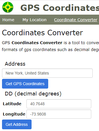
Latitude and Longitude Finder
The app allows you to both convert the address into GPS coordinates of location, and vice versa. A big advantage is that with geolocation enabled and the resolution given in your browser, the service can determine your coordinates. All of this is displayed on the map, and the address is determined with street precision.
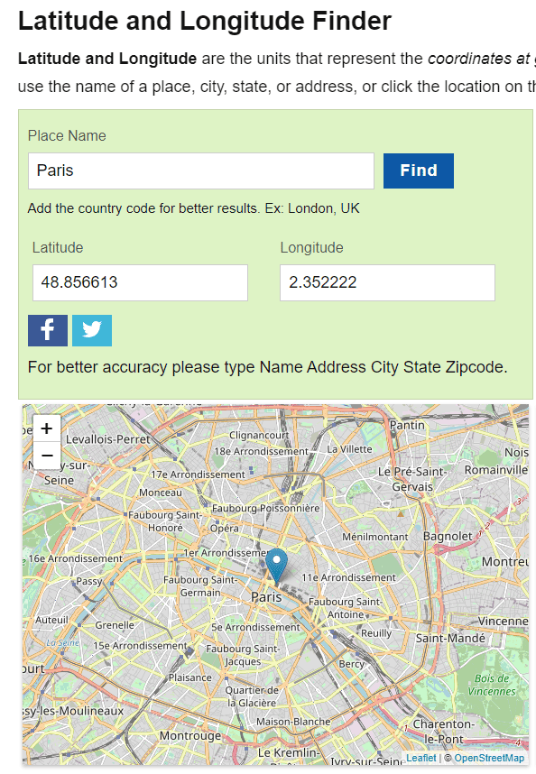
To check your current GPS coordinates:
- Go to gps-coordinates.org.
- Open the map and set the point to where you are.
- As a result, the data will be displayed in DD (decimal degrees) and DMS formats.
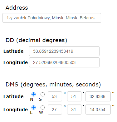
- Going into Coordinates Converter, you can convert coordinates from one format to another.
The website has a detailed instruction on how to use it. You can
- convert address to coordinates,
- use the function "where I am",
- find out your IP address,
- navigate by states (relevant to users from the U.S.).
This service is also represented by the Android app. You can download it from Play Market via the link.
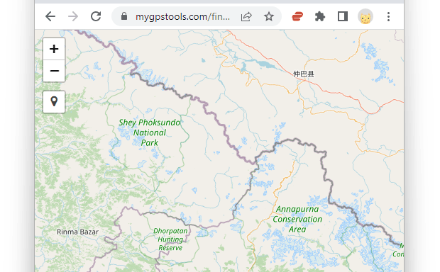
MyGPSTools Finder
MyGPSTools Finder is a free browser-based GPS location finder. It shows your current latitude and longitude, estimated accuracy, DMS coordinates, and quick links for Google Maps, Apple Maps, and Waze.
Use it when Google Maps shows the wrong current location and you want to compare Maps with the raw location detected by your browser.
How to use MyGPSTools Finder:
- Open the GPS Location Finder.
- Tap Find My Location.
- Allow location access in your browser.
- Compare the detected latitude, longitude, accuracy, and map position with Google Maps.
Why do I need to perform GPS calibration?
It's quite difficult to overestimate the need to set up a GPS connection. Calibration allows you to:
- check the functionality of your gadget navigation module (GPS receiver);
- fix “google maps showing wrong location” error on Android;
- find the most favorable place to connect to the network with no signal overlap;
- find out more information about satellites: their availability, country affiliation, and exact coordinates.
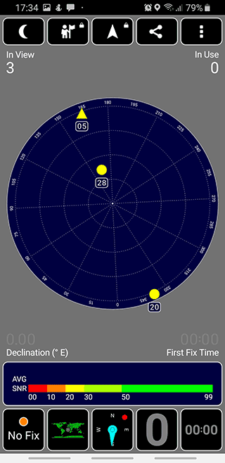
Setting up GPS via GPS Test app
GPS Test is a perfect match if you need to test a mobile device running under the Android platform. The app is convenient because it allows you to check the capabilities of your GPS receiver without an Internet connection.
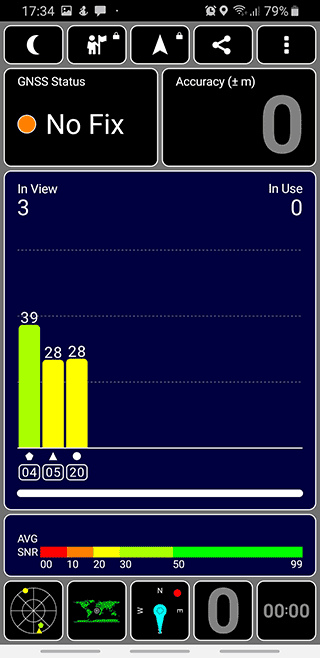
GPS Test uses the AGPS service for calibration, which in its turn corrects a bad GPS connection. The interface is more than merely intuitive if we can say so, which is definitely a significant advantage.
The app has six screens with the following information. LetРІР‚в„ўs highlight its most important features:
- A chart illustrating the GPS signal strength for each available satellite in the list, as well as signal stability with the GNSS network;
- A compass showing the position of satellites in the sky in the SkyView mode;
- A regular compass helping with the navigation around an open area;
- A map of the world and your current location as a specific place with a caption. You can also see the current position of the Sun and the transition curve between day and night on the map;
- The current speed, altitude, and direction are displayed in text format;
- Sunrise and sunset times in current coordinates; local time.
How to calibrate GPS connection on Google Maps
GPS Status & Toolbox provides its users with sensor and GPS data such as:
- Satellite coordinates and signal strength;
- Battery status;
- The satellite speed and acceleration;
- Altimeter and speedometer.
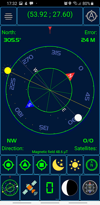
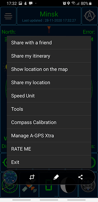
With the app, you can find out your exact location in any coordinate format and share it with your friends. In addition to the calibrator, Status & Toolbox has a built-in magnetic compass. The app also allows you to reset or download A-GPS data via which you can adjust the GPS receiver.
You can download the utility via the link
Related guides
More useful articles from the Google Maps Guides topic.
- Google Maps location sharing: how to fix on iPhone / Android
If Google Maps location sharing says someone is offline or stops updating, this guide explains what usually causes it and what to check on iPhone and Android.
- What speed does Google Maps use to calculate driving time and ETA?
Learn what Google Maps actually uses to estimate travel time, including speed limits, live traffic, GPS location, and route distance. See what affects ETA, what doesn’t, and how the speed limit feature works.
- How to Clear Google Maps Recent Searches from Search History
Learn how to delete recent searches from your Google Maps history on Android, iOS, or PC. Troubleshoot issues with Google Maps search history not deleting
- 3 ways to download an image via Google Maps
3 convenient ways how to download to your phone or computer an image stored on the Google Maps service.
- No sound on Google maps: how to fix on iPhone or Android
We will list all the problems with sound settings and show you how to fix them on iOS or Android
About MyGpsTools Editorial Team
MyGpsTools publishes practical guides about GPS apps, maps, navigation tools, EXIF photo metadata, satellite imagery, Android Auto, Apple CarPlay, ZIP code maps, and location-based technologies. We focus on clear instructions, practical checks, official documentation, and reader feedback.