Best GPS navigation apps with offline maps for Canada
Best navigation apps for iOS / Android to travel in Canada. Offline maps, traffic information for Ontario, Quebec, Toronto, Montreal
In this selection, you will find navigation apps that will help you if you are travelling in Canada. They include maps, directions, traffic information, and more. Basically, everything that will be useful when traveling on Canadian roads. Navigation apps can be used by drivers as well as pedestrians and tourists.
The best GPS navigators for Canada:
Table of contents
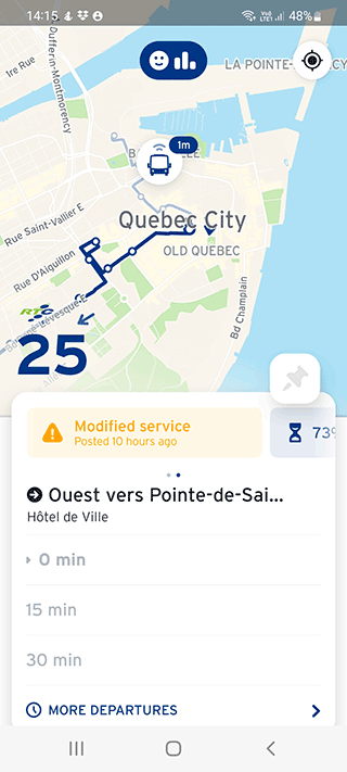
Transit - Subway & Bus Times

App
App rating: 4.5 out of 5
- Price
- €2.89 - €25.00 per item
- Developer
- Transit, Inc.
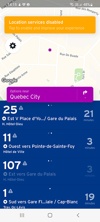
The Transit app gives you accurate information about public transit traffic in Toronto, Montreal, Vancouver, Calgary. It is easy to build the fastest and most rational route for trip you planned. The turn-by-turn navigator helps you navigate in unfamiliar areas.
Turn on the mobile Internet to get the latest updates. If there is no access to the network (for some reason), the app will display the transport schedule and travel plan in offline mode.
Pros of the navigation app:
- Access to subway maps;
- Route planner;
- You can pay for transportation services, compare prices;
- It shows bike rentals and carsharing.
Cons:
- After the update, users noticed that the app is performing worse;
- A limited number of cities that the app supports.
"Transit" analyzes and offers several path options so that the driver chooses the most convenient and fastest way to travel. It makes combined trips in different ways, for example, "subway + cab", "train + bus". All major Canadian cities are supported.
The app will tell you in what time your transport will arrive. There are sound notifications: Transit will remind you when you need to hurry to the stop or get out of the car.
The app is available not only in Canadian cities, but also in North America, Europe, Australia, and New Zealand.
OsmAnd

App
App rating: 4.6 out of 5
- Price
- €1.83 - €29.99 per item
- Developer
- OsmAnd
Popular travel app for exploring Canadian cities such as Ottawa, Edmonton, Mississauga, Toronto, etc., on the basis of which many amateur navigators are created. The main advantage is Canadian offline maps.
On the main screen you are immediately greeted by a global map. To search for an address, just tap on the magnifying glass in the upper left corner of the screen, and enter the address or name of a place there. It is recommended to include geolocation for more accurate determination.
Also one of the pluses is the widest possible settings. Speed cameras, voice navigation, toll road avoidance, fuel saving mode, etc.
OsmAnd is the benchmark app among simple user-created navigators for Canada. In places it may be inferior to Google Maps or other major services, but over the years it is this voice-activated navigator that has earned popularity among its audience.
Waze for Canada

App
App rating: 4 out of 5
- Price
- Free
- Developer
- Waze
Waze is a social app for navigating through cities and provinces in Canada and other countries. Maps can be edited by users themselves - they can add their own information about traffic jams, accidents, and any changes to the map. Thus, with the help of drivers, the app becomes better and more convenient for all users.
To improve Waze service, you need to run the app each time before a trip. It will automatically collect basic information about roads.
The quality of maps in a particular canadian region depends on the number of users and their activity. For example, you can use Waze in Winnipeg, Brampton, Quebec City and such canadian provinces as Ontario, Quebec, or British Columbia.
The more drivers drive with the app open, the more accurate and informative the map becomes.
Pros:
- Online maps are updated, the app shows all the latest changes;
- The app remembers the speed, direction, turns, analyzes the collected information, finds errors, improves the road map;
- Works all over the world, including Canada;
- You can be informed about police posts and speed cameras, in case if other drivers have already marked them on the map.
Users get bonus points that increase their level in the app. The more a driver warns about conditions on the road, the higher his rank becomes. This custom game motivates active participation in improving the map, with drivers competing to be the best "wazer" in their area.
Cons:
- Traffic information is not always available in Canadian cities;
- There are not enough Waze users in Canada to make the app as informative as possible;
- Waze does not work with bike lanes, public transit and truck lanes.
The app is suitable for smartphones and tablets on Android, iOS, Windows, and BlackBerry platforms.
Sygic GPS Navigation & Maps
App
App rating: 4.5 out of 5
- Price
- €0.69 - €59.99 per item
- Developer
- Sygic.
The navigator from Sygic is used by drivers all over the world. The list of available countries constantly expands. The app is distributed to countries in Africa, Asia, Latin America, Europe, USA and Canada.

The main purpose of the app is to make every car owner on the planet a user of Sygic GPS Navigation & Maps. Now the service is used by more than 125 million people.
When traveling in Canada, the app can be used offline - it has a database of maps for offline navigation for some regions, for example:
- Alberta
- Manitoba
- Saskatchewan
- Nova Scotia
- New Brunswick
... and so on.
Driving and walking routes are easy to plan from your smartphone, even without mobile Internet. When connected to the network, real-time map updates become available - the situation with traffic jams and incidents, information about traffic police posts and cameras.
Canadian maps are broken down by region with detailed information. For tourists who are planning to visit unfamiliar places in Canada, Sygic becomes a reliable assistant - it contains up-to-date information for travelers with detailed routes and constant updates.
Pros:
- Voice-assisted navigation with step-by-step instructions;
- Information about the different points of the route;
- Warning of speed cameras and areas with speed limits.
Cons:
- Complex interface with many options;
- free trial period of only 7 days.
In addition to GPS navigation, Sygic offers a number of other products for the convenience of the driver and the tourist. For example, Head-Up Display projects information from the navigator on the windshield of the car. TripAdvisor and Booking services help travelers learn about tourist destinations, read reviews and recommendations.
Maps.me

App
App rating: 4.3 out of 5
- Price
- Free
- Developer
- MAPS.ME (CYPRUS) LTD
Maps.me - is a free navigation app, which is convenient to use for voice navigation, tracking traffic jams on European routes, in Canada and the United States.
To get information about traffic jams on the map, tap on the traffic light icon - the screen will display routes highlighted in green, yellow or red.
For the correct operation of Maps.me and the display of traffic jams need a stable Internet connection on your mobile device.
Top Canadian regions you can use maps.me in offline mode:
- Ontario
- Quebec
- British Columbia
Navigation Pro

App
App rating: 4.6 out of 5
- Price
- €2.99
- Developer
- Smartwatch Studios
The Navigation Pro app from Samsung has a feature designed exclusively for Galaxy smart watch users. The information from the navigator is synchronized with the watch and displayed on the screen.
The app is designed to display information on the watch display in the most convenient format. Its function helps you not to get lost in unfamiliar places in Canadian provinces, cities and villages - an arrow will always show the direction to the right place. The units of distance measurement can be adjusted.
Navigation Pro is the best for visiting such places in Canada as:
- Niagara Falls
- Banff National Park
- CN Tower
- Stanley Park
- Old Quebec
Pros:
- Keep track of direction without taking your eyes off the wheel - just by looking at your hand;
- If you lose your watch, the navigator will help you find it quickly and easily.
Cons:
- App is paid;
- Autostart function - turns on the watch itself, when it is not necessary.
Navigation Pro works on smart watches from Samsung, as well as on any smartphones and tablets with Android.
Gaia GPS: Offroad Hiking Maps

App
App rating: 4.6 out of 5
- Price
- €2.89 - €74.99 per item
- Developer
- TrailBehind Inc.
Gaia GPS navigator has many fans around the world and is popular with drivers, travelers and guides in Canada.
It is convenient for visiting some touristic places such as:
- Jasper National Park
- The Canadian Rocky Mountains
- The Bay of Fundy
- Ottawa
- Quebec City
The app saves traveled routes, geo tagged photos, destinations, and maps of Canada. All of this can be shared with friends by sending a link via email or social media directly from the app. You can save data to cloud storage.
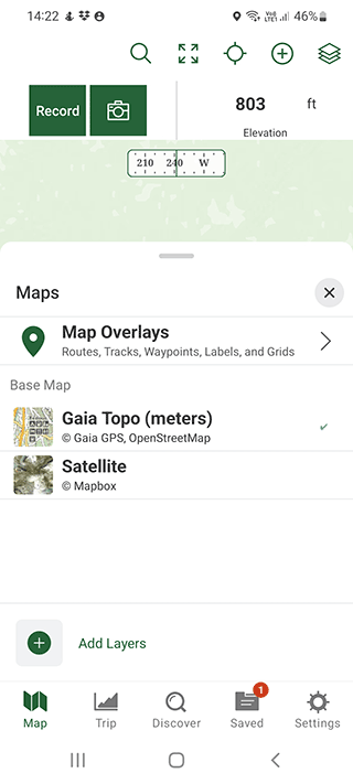
Pros:
- Gaia has a variety of Canadian maps loaded - road maps, topographic maps, aerial maps;
- You can save an unlimited number of maps for yourself and use them without Internet.
- Settings, such as units of distance and speed, and type of coordinates, are available.
Cons:
- You can download maps of the regions of Canada only in the paid version;
- Sometimes the app is redirected to Google Maps.
The desktop version allows you to use the service on your computer, by logging in and registering at www.gaiagps.com. Your profile with saved routes, maps, photos can be synchronized on all devices that use the service.
TomTom AmiGO

App
App rating: 4.4 out of 5
- Price
- Free
- Developer
- TomTom International BV
TomTom AmiGO plans the best route based on the current situation on the road. Traffic jams and road repairs are alerted in real time via voice navigation system. In addition, the user is notified about speed cameras and speed limits on a particular section of road.
Some Canada's most scenic drives you can use TomTom AmiGO for:
- Cabot Trail, Nova Scotia
- Icefields Parkway, Alberta
- Viking Trail, Newfoundland and Labrador
The app works in all Canadian regions and cities, but some regions require downloading a local map. For example:
- Vancouver, British Columbia
- Calgary, Alberta
- Ottawa, Ontario
- Edmonton, Alberta
TomTom AmiGO essential features:
- Voice notification of speed cameras - mobile and stationary;
- Updating the data in real time at the expense of the participants of the app community;
- Notification of dangerous road sections - repairs, road potholes, other problems;
- No ads in the app - nothing distracts the driver from monitoring the situation on the road.
Pros:
- Detailed route making with bypassing of possible problem areas
- Intuitive interface
Cons:
- Maps do not work in offline mode
Google Maps
App
App rating: 4.7 out of 5
- Price
- Free
- Developer
- Google LLC
The app displays data on traffic jams on streets of Canada. Similar to the browser version, in the mobile app you can activate the map of traffic jams through the menu "Layers".
To display traffic jams you need to tap the "Layers" icon, select the display mode and specify the layer with traffic jams.
It should be noted that the voice navigation app, for objective reasons, can not display a map of traffic jams and congestion in all countries and cities. Nevertheless, it is possible to get information about traffic jams for major Canadian roads.
Information about road works, road closures and other events that affect the speed of cars, is also available on Google Maps.
Here WeGo

App
App rating: 3.6 out of 5
- Price
- Free
- Developer
- HERE Apps LLC
When you first start the app itself will help you with the settings of voice navigation. It will turn on the traffic tracking mode, navigation, and will tell you what permissions are required for further work.
The maps in the app are their own, that is, not based on Google, Waze, etc. The interface is simple and intuitive. On the main screen, you can immediately enter your destination and route to it, or view your location.
You can also save your home address, work, and other addresses in Canada to your favorites.
Using a special button, you can download offline maps to use the app in Canada even without internet access. Download a map of the region you want in advance to navigate by it in the future.
In the settings of voice navigation you can choose the type of fuel you use, the design of the app, the units of measurement (by default they are selected automatically, depending on the country).
When selecting the end point, you only need to click on the inscription "route" to pave the way for a car, pedestrian, cab or public transport in Toronto, Montreal, or Vancouver.
Related guides
More useful articles from the Navigation Apps & Offline Maps topic.
- Best Garmin Hiking GPS Units - Handheld GPS Navigation Reviews 2025
Compare top Garmin handheld GPS units for hiking. Expert reviews of portable GPS devices with topographic mapping, waterproof design, and long battery life.
- Top Walking Apps in 2025: The Smartest Way to Step Up Your Walk
Discover the best walking apps in 2025. Complete guide to GPS navigation apps for walking directions, featuring top-rated apps for Android and iPhone users
- Best Driving Apps for Android: Essential Tools for Every Journey
Discover the top driving apps for Android that improve safety and navigation. From free driving apps to premium options, find the best apps for driving on your next road trip or daily commute.
- GPS Navigation Apps and Tools for Students: Campus Navigation, Study Abroad, and Outdoor Education
Comprehensive guide to GPS navigation apps, offline mapping tools, and location-based technology for college students: campus navigation, study abroad programs, outdoor recreation, and field research applications.
- How to Use GPS Without Data and Internet Access: FAQ for Android / iOS
Does GPS work without Wi-Fi or Internet? Does it use phone data when GPS is turned on? How does GPS work on iOS and Android phones? Learn how to achieve full-fledged GPS navigation without data
About MyGpsTools Editorial Team
MyGpsTools publishes practical guides about GPS apps, maps, navigation tools, EXIF photo metadata, satellite imagery, Android Auto, Apple CarPlay, ZIP code maps, and location-based technologies. We focus on clear instructions, practical checks, official documentation, and reader feedback.