Does Waze show cops? Is it legal to use the feature?
Many drivers would like to see Waze show cops on the road. How the police alert feature works, enabling police detection. Alternative GPS apps that show cops
Here's how Waze's police-reporting feature works, and how it's different from other apps.
Waze app shows the driver where red light / speed cameras are installed, informs about accidents and traffic jams on the road. However, some of the useful information features users do not know about.
Many drivers would like to see in Waze the function of displaying police officers on the road. In this article, we will show you how the cop detector feature works, how to enable it, and what its benefits really are.
Table of contents
How the Police Alert feature works
Waze does not report the nearest police checkpoints on the road.
However, Waze users (wazers) do inform others on the road about police checkpoints. They do this on their own initiative. In this way, other Waze users get up-to-date information about traffic cops and police.
You can find police officers on the road on a set route through a live map, where users post data about incidents, traffic jams, and report police ahead.
Related Waze Guides
- Does Waze work offline?
- How much data does Waze use?
- Does Waze have satellite view?
- How to change Waze voice
How do I turn on police detection in Waze?
Here is a quick tutorial to activate police alert feature:
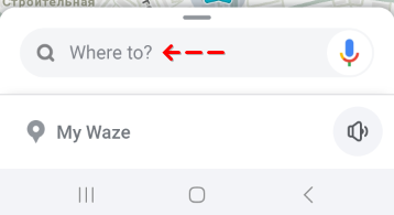
Step 1. Install and run the Waze app, then tap the magnifying glass button.
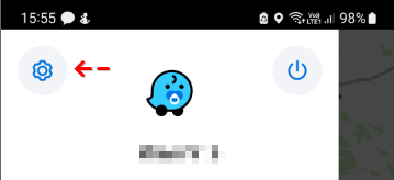
Step 2. Go to Settings (gear icon) > select Send report.
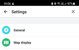
Step 3. Tap on the Map display menu bar and open the Reports section.
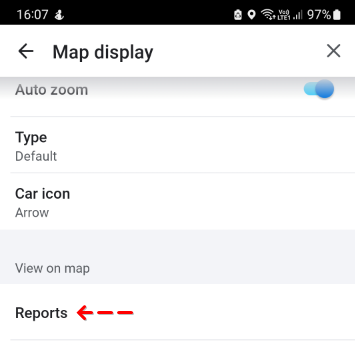
Step 4. Tap on the Show on map option in the Police section.
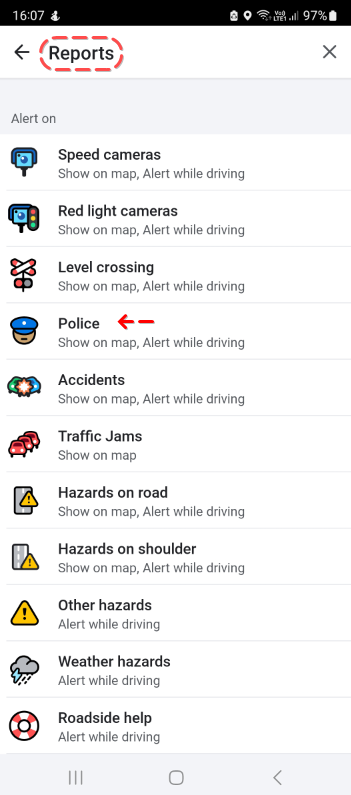
Step 5. Enable Show on map and Alert while driving features.
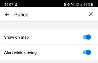
After these steps Waze will show the police behind you on the map.
How do I report the police?
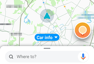
Step 1. Open the Waze app.

Step 2. Tap the the gray circle in the bottom-left and then orange circle button.
Step 3. Tap the Police icon.
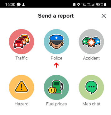
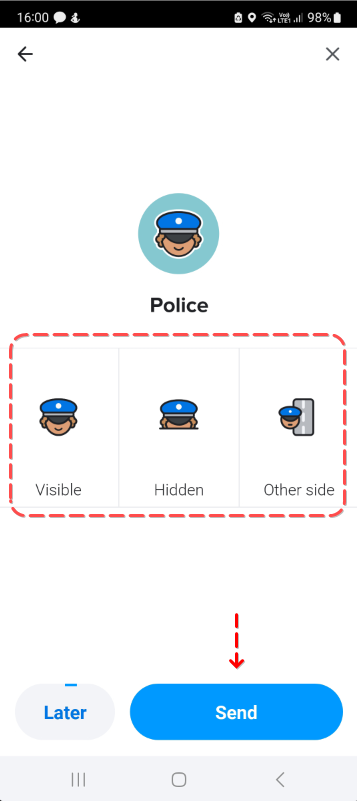
Step 4. Set a point on the map and give the location of the police.
Step 5. Choose the Visible / Hidden / or Other side option.
Step 6. Tap the Send button.
How accurately does the police discover function work
It cannot be guaranteed that the police information will be correct. Waze does not check the accuracy of this information. However if a wazer has reported police and the information is incorrect (or the location of the police has changed) then other users will be able to correct the data. All changes will be available in the Waze app via real-time notifications.
Be sure to check when the information appears on the map - the police officers checkpoint may have been moved to a different location.
Is the feature illegal?
The feature is perfectly legal. You can tell other users where the police are.
For example, if drivers need to be notified urgently of an accident, information about the location of the police can help solve the problem as quickly as possible.
Also, drivers may need urgent assistance (to prevent a crime or provide emergency medical care) - in such cases, the police (in theory) may just save a life.
Police detection feature: Pros and Cons
Pros:
- Other wazers tend to provide reliable data
- The feature is easy to turn on via settings
- Police Report allows you to focus your attention
Cons:
- Data requires verification
- Not all checkpoints are visible on the map
- Police stakeout data is only valid for a certain amount of time
TL;DR
Waze does not detect police locations on the roads. Users self-publish information about police checkpoints on the map. This information is not verified, but other users can correct it.
The police detection feature works perfectly legally in Waze. It is designed to make drivers more attentive and prepare to slow down if necessary.
In any case, it is necessary to comply with the law and not to exceed the maximum allowable speed.
Alternative GPS apps that shows cops on map
Police Detector - Speed Radar
Specialized free app for obtaining data on speed cameras and police patrols. The app works without registration in all more or less known countries.
After launching the app and turning on the GPS, you will see marks on the map. These are the places where there are speed cameras and police roadblocks. Users of the app can independently inform other traffic participants about such events.
Additional functions: information about traffic jams, police checkpoints, Radar Detector mode, car speed conorol.
Radarbot Speed Camera Detector
Another GPS app to see where cops are on the map and also informs about hidden speed cameras. The difference from other radar detectors is that this app works in real-time mode and tells you where police are right now.
Other features of the Radarbot app:
- works together with other gps navigators
- supports voice control
- supports smart gadgets
- works in all European countries, U.S., Australia
- bunch of settings.
Related guides
More useful articles from the Waze Guides & Troubleshooting topic.
- Does Waze Work Offline?
Learn how Waze works offline on Android and iOS. Understand what you can cache, how to prepare routes in advance, native cache-clearing methods, and when to use true offline alternatives like Google Maps or HERE WeGo.
- How to Change Waze Voices: Official, Funny, and Custom Voice Packs
Learn how to change the voice in Waze on iPhone and Android, what voice packs are still available, how custom voices work, and what to do if a voice pack doesn’t show up.
- How much data does Waze use on Android and iOS
Waze usually uses very little data for navigation, but the exact amount depends on how long you drive, how often the app refreshes traffic data, and whether you keep it running in the background.
- How to Access and Use Waze Satellite View
Waze does not offer a true satellite map layer. Here’s what that means in practice, how to check alternative apps like Google Maps and Apple Maps, and the fastest way to get satellite view when you need it.
- Waze Error Calculating Route: Why Waze Can’t Find Your Route and How to Fix It
Waze can’t find a route or shows “error calculating route”? Learn how to fix routing errors step by step: internet, GPS, long trips, app bugs and more.
About MyGpsTools Editorial Team
MyGpsTools publishes practical guides about GPS apps, maps, navigation tools, EXIF photo metadata, satellite imagery, Android Auto, Apple CarPlay, ZIP code maps, and location-based technologies. We focus on clear instructions, practical checks, official documentation, and reader feedback.