How to Access and Use Waze Satellite View
Waze does not offer a true satellite map layer. Here’s what that means in practice, how to check alternative apps like Google Maps and Apple Maps, and the fastest way to get satellite view when you need it.
Waze still does not have a built-in satellite view, and that hasn’t changed in any useful way for regular users. If you’re looking for an actual satellite map layer inside Waze, you won’t find a toggle for it on iPhone or Android.
What Waze does give you is a road-focused navigation screen. If you want satellite imagery, you’ll need to switch to another app such as Google Maps or Apple Maps. That’s the practical answer.
Quick Answer
Waze does not support satellite view in its map display. There’s no setting to turn it on in the app, and regular users shouldn’t expect that to change soon. If you need satellite imagery, open Google Maps or Apple Maps instead. Those apps let you switch to satellite view directly, while Waze stays focused on turn-by-turn navigation.
Table of contents
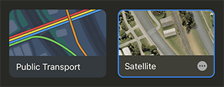
Enabling Satellite View Through Alternative Navigation Apps
Since Waze doesn’t offer satellite map functionality directly, the usual workaround is simple: use another map app when you need aerial imagery.
Google Maps and Apple Maps both include satellite layers, and in most cases they’re the faster option if you just want to check an area from above. The exact layout changes a bit by device and app version, but the steps below still reflect the usual path.
Toggle Satellite Mode on Google Maps (Android / iOS):
Step 1. Open the Google Maps app
Step 2. Ensure WiFi or mobile data is enabled
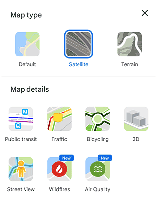
Step 3. Tap the layer toggle icon in the interface

Step 4. In the Map type section, select the Satellite option
Step 5. Return to the map by tapping anywhere on the screen
Step 6. Google Maps will now display the satellite map view for your route
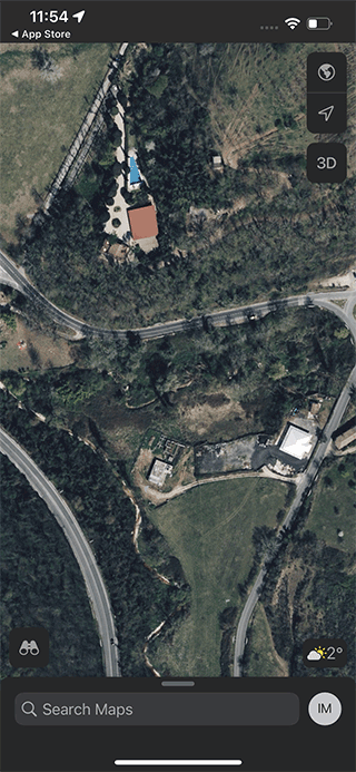
Change to Satellite View in Apple Maps (iOS):
Step 1. Open the Maps app
Step 2. Tap the 'I' (information icon) button in the upper right corner of the display
Step 3. In Map Settings, select the Satellite view option
Step 4. Return to the map by tapping on an empty space on the screen
What Waze Does Instead
This is where some people get tripped up. Waze is built around navigation, traffic, hazards, and route changes. It is not trying to be a satellite imagery app.
So if you open Waze expecting aerial photos or a map layer that looks like Google Maps satellite mode, you’ll be disappointed. Waze keeps the interface stripped down on purpose, which is useful while driving, but it also means fewer map display options.
If you only need directions and traffic alerts, that setup works fine. If you want to inspect a neighborhood, parking lot, driveway, or nearby landmark from above, Waze isn’t the right tool.
When to Use Google Maps or Apple Maps Instead
Use Google Maps if you want a satellite layer on both Android and iPhone and don’t mind a few extra taps.
Use Apple Maps if you’re already on iPhone and want a quick switch to satellite view without installing another app.
Neither app is the same as live satellite video. You’re looking at map imagery, which can vary by location, date, cloud cover, and how recently the area was updated. That’s normal.
Why People Keep Looking for Satellite View in Waze
The request makes sense. A satellite layer can help if you’re trying to identify entrances, building outlines, parking areas, or the layout of a place before you arrive.
But Waze has always leaned toward simple navigation rather than map exploration. That’s why this feature keeps coming up in user discussions, and also why people are still looking for a workaround in 2026.
Summary
Waze does not currently include a satellite view option, and there’s no hidden setting to turn it on. If you need satellite imagery, the quickest fix is to use Google Maps or Apple Maps instead.
For everyday driving, Waze still does what it’s meant to do. For looking at an area from above, it’s the wrong app.
FAQ
Does Waze have a satellite view in 2026?
No. Waze still doesn’t offer a satellite map layer for regular users.
Can I turn on satellite mode in Waze on iPhone or Android?
No. There isn’t a setting for satellite mode in either version of the app.
Why doesn’t Waze have satellite view?
Waze is built mainly for turn-by-turn navigation, traffic, and road alerts. Satellite imagery has never been part of its standard map display.
What app should I use instead of Waze for satellite maps?
Google Maps is the most common alternative on both Android and iPhone. Apple Maps is also a good option on iPhone.
Is satellite view the same as live satellite imagery?
No. Satellite view usually means map imagery or aerial imagery, not a live feed.
Can I use Waze offline if I just need the route?
Sometimes only partially. Waze doesn’t work like a full offline map app, so it’s not a good substitute if you need reliable offline navigation.
Does Google Maps satellite view work without internet?
Not reliably. Satellite tiles usually need a connection, and availability depends on what has already been loaded or saved.
Related guides
More useful articles from the Waze Guides & Troubleshooting topic.
- Does Waze Work Offline?
Learn how Waze works offline on Android and iOS. Understand what you can cache, how to prepare routes in advance, native cache-clearing methods, and when to use true offline alternatives like Google Maps or HERE WeGo.
- How to Change Waze Voices: Official, Funny, and Custom Voice Packs
Learn how to change the voice in Waze on iPhone and Android, what voice packs are still available, how custom voices work, and what to do if a voice pack doesn’t show up.
- How much data does Waze use on Android and iOS
Waze usually uses very little data for navigation, but the exact amount depends on how long you drive, how often the app refreshes traffic data, and whether you keep it running in the background.
- Waze Error Calculating Route: Why Waze Can’t Find Your Route and How to Fix It
Waze can’t find a route or shows “error calculating route”? Learn how to fix routing errors step by step: internet, GPS, long trips, app bugs and more.
- How to Add Your Business Location on Waze Map: Complete Setup Guide
Step-by-step instructions for Android or iPhone on how to add business to Waze and create a business listing on the Waze map
About MyGpsTools Editorial Team
MyGpsTools publishes practical guides about GPS apps, maps, navigation tools, EXIF photo metadata, satellite imagery, Android Auto, Apple CarPlay, ZIP code maps, and location-based technologies. We focus on clear instructions, practical checks, official documentation, and reader feedback.