How to get GPS coordinates from a photo. EXIF data location
Extract GPS coordinates from a photo using EXIF metadata. Find latitude and longitude, check where a picture was taken, and see why location data may be missing.
If a photo still contains EXIF GPS metadata, you can extract its latitude and longitude and identify where the picture was taken. If the image was re-saved, compressed, screenshotted, or shared through some apps, the location tag may already be missing.
Table of contents
EXIF data viewer
The fastest way to check whether a photo still contains GPS coordinates is to open it in the EXIF Data Viewer.
MyGPSTools EXIF is a free online service that lets you easily view all the metadata embedded in a photo, including GPS information. No software installation is needed. The service supports all popular image formats, such as JPG, PNG, and HEIC.
How to Use MyGPSTools Location Viewer:
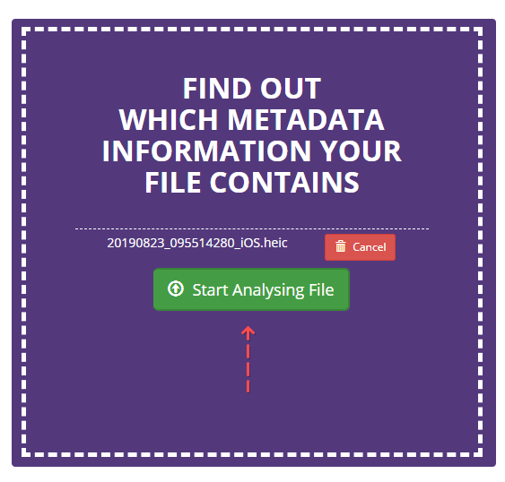
Select the photo you want to analyze from your phone or computer.
Click the "Choose File" button to upload the image and extract GPS coordinates.
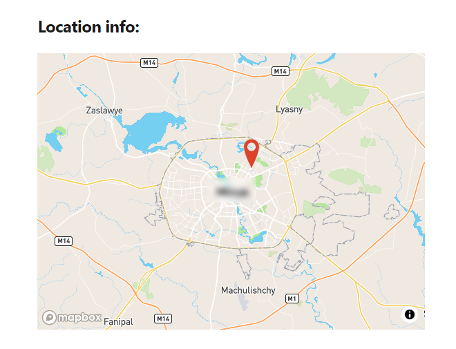
If the photo contains geolocation data, the coordinates will be displayed on a map with a marker. You can zoom in and out as needed.
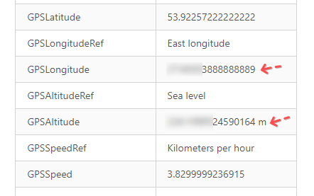
To find the exact coordinates, refer to the table showing the GPSLatitude and GPSLongitude values.
Supported Platforms, Devices, and Photo Formats
| OS / Platform | Version / Model | Photo Format |
|---|---|---|
| Windows | Windows 10 | JPG / JPEG |
| Windows | Windows 11 | JPG / HEIC |
| iOS | iOS 17–19 | HEIC / Live Photo |
| iPhone | iPhone 13 / 14 / 15 | HEIC / JPG |
| Android | Android 12–15 | JPG |
| Android / One UI | Samsung Galaxy A53 | JPG |
| Android / One UI | Samsung Galaxy S24 | JPG / HEIC |
| Android | Google Pixel 6 / 7 / 8 / 9 | JPG |
| Android / ColorOS | Oppo phones | JPG |
| Sony camera / desktop | Sony Alpha / Cyber-shot | JPG / ARW |
| Sony Action Cam | Sony HDR-AS30 / AS33 | JPG / MP4 frame |
| DJI / desktop | DJI Mini / Air / Mavic | JPG / DNG |
| GoPro / desktop | GoPro HERO 8–12 | JPG / MP4 |
| DSLR / mirrorless camera | Canon / Nikon / Sony | JPG / RAW |
| Google Photos | Web / Android / iOS | JPG / HEIC |
| Apple Photos | iOS / macOS Photos app | HEIC / JPG |
| macOS | macOS Sonoma / Sequoia | HEIC / JPG |
| Linux | Ubuntu / Debian | JPG / HEIC |
| Windows / macOS | Photoshop / Photoshop Elements | JPG |
| Web / JavaScript | Browser upload form | JPG / HEIC |
| Node.js / CLI | ExifTool / exifr | JPG / HEIC |
| Google Maps | Web / mobile | Lat/long data |
| Mobile | Android / iPhone | JPG |
| Mobile / desktop | Any modern phone | JPG |
| Mobile | iPhone / Android | HEIC / JPG |
| Any OS | Any device | JPG / HEIC |
| Android / iOS | WhatsApp / Telegram | JPG |
| Google Drive / iCloud | Web / mobile | JPG / HEIC |
| Windows | Windows 10 / 11 file properties | JPG |
| iOS / Windows | iPhone + Windows PC | HEIC |
| Any OS | Any device | JPG / JPEG |
Photo GPS Extractor
If you've used Quick Photo GPS Extract before, you know it was a simple tool with one main function: showing the location of your photos.
Photo GPS Extractor 9.0 brings more features and functionality to the app.
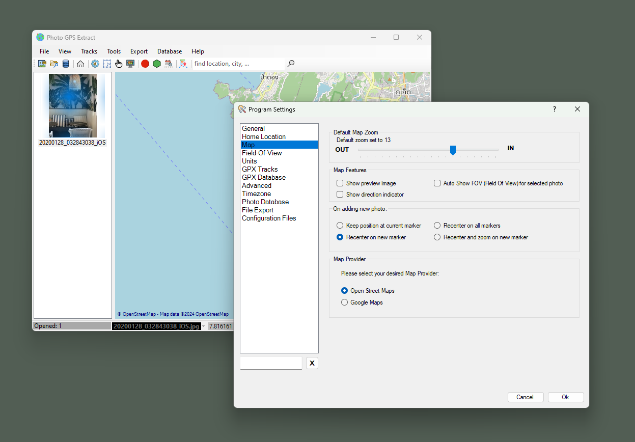
Let's take a look at some key features of Photo GPS Extractor:
Photo GPS Locator: A tool designed for landscape photographers to pinpoint and mark specific points of interest in panoramic images.
Advanced Map Interface: The software integrates with GMAP.NET and OpenStreetMaps to display coordinates seamlessly.
Convenient Photo Navigator: Displaying thumbnails of uploaded photos. You can open them on the map with just a click.
Interactive Photo Markers: it helps to check the photo’s properties, calculate the sun's position at the time the photo was taken, visualize the camera’s field of view, and more.
GPX Data Storage: it allows you to manage, search, and sync GPX tracks with the map for easy navigation and detailed analysis.
Ruler Tool: this feature calculates real-world dimensions using focal length and GPS coordinates, making it ideal for geographers measuring landscapes or objects in images.
Batch Extractor: process entire folders at once, extracting GPS data and exporting it in formats such as KML, CSV, and HTML.
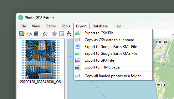
Overall, Photo GPS Extractor 9.0 is a powerful and comprehensive tool for photographers and geographers alike.
Download Photo GPS Extractor 9.0ExifTool
ExifTool by Phil Harvey is a great software available for Mac and Windows for free. Via it, you can extract GPS coordinates from photos.
It works with most popular media formats, including photos and video, and extracts GPS data from the EXIF. There are a dozen other useful features.
Let's note some of the features of ExifTool:
- many supported media formats
- support for a wide range of digital cameras and cell phones
- GPS track support for video formats
- (you'll find a table with a description on the exiftool.org website)
The program works on Windows, Mac, Linux, etc. Windows platform requires no additional libraries, and Mac OS / Linux have Perl built-in.
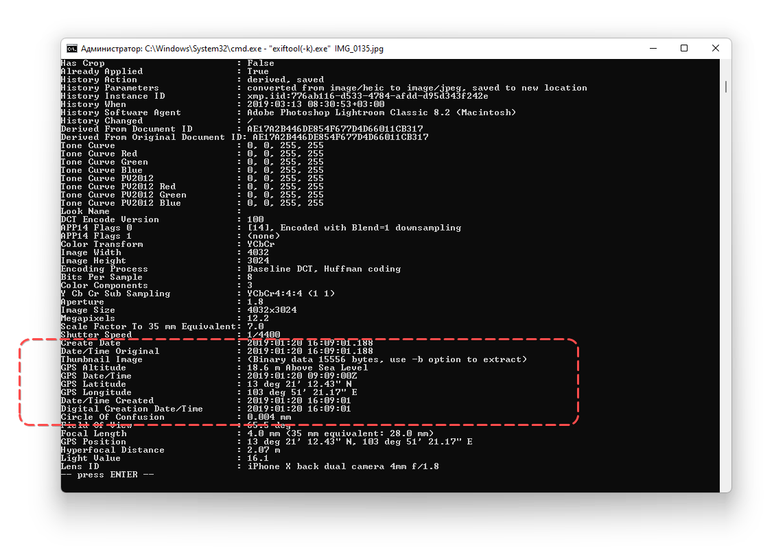
ExifTool has no graphical interface, you will have to open it from the command line to see the data.
Video instructions:
- (for Windows) Move "exiftool.exe" to the "C:\WINDOWS" dir (or any other PATH directory). The Mac/Linux installs do this automatically.
Note. Alternatively, you can just drag and drop the file onto exiftool(-k).exe, which is much simpler if you don't want to add extra command-line arguments.
- Open Command Prompt from the Run menu or any other tool (for example Total Commander, by entering cmd). In the case of Mac/Linux use command prompt / any terminal app.
- Type exiftool.exe command IMG_0135.jpg, where IMG_0135.jpg is the name of the file.
- ExifTool will display all the information about the photo, we are most interested in GPSLongitude and GPSLatitude data.
See the instructions on the official website.
At the moment ExifTool is probably the most powerful tool for reading EXIF data. We advise you to study the program thoroughly, it definitely saves time with large amounts of data.
Onlineexifviewer
onlineexifviewer is a simple online service developed by Andy Feliciotti. The service allows you to read EXIF data from photos. It works through a browser. It is easy to use Onlineexifviewer both on your iOS / Android phone and computer.
The following photo formats are supported: JPG, TIFF, PNG, WebP and HEIC. Thus, you can analyze everything that was taken with a mobile phone and digital camera.
Note. If the GPS recording was disabled, you will not know where the picture was taken.
Uploading works via drag-n-drop method. It allows you to extract the following data: Camera Model, Location Details, Date and Time, all about the coordinates.
How to use the service:
- Go to Onlineexifviewer.
- Click on Select image button

- Select a photo to analyze
- In the left column, Camera Location Details, the coordinates of the photo are displayed, as well as a mini-map with the point where the photo was taken
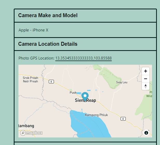
- In the right column (All Photo EXIF Data) you can see all the info of the photo
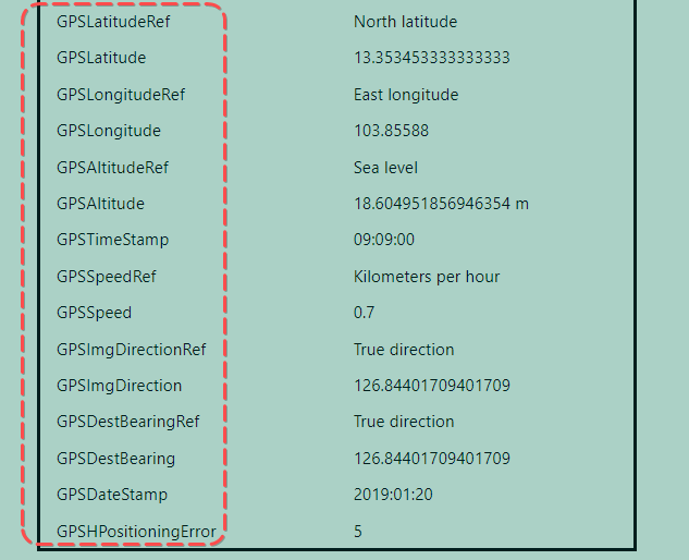
- Check GPSLatitude, GPSLongitude and other parameters with GPS postfix: Latitude, Longitude, Altitude, TimeStamp, Speed, ImgDirection, DestBearing, DateStamp, HPositioningError.
Where the photo GPS data is stored
Information about the coordinates is embedded in metadata, which can be found in photo properties. In order to read the metadata, check the properties of the desired file.
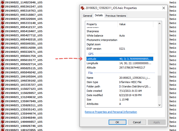
Instructions for Windows 7 - 11
This method does not require a specialized program, just go to the file properties and open the tab with the EXIF data.
Getting GPS coordinates from a picture for Windows:
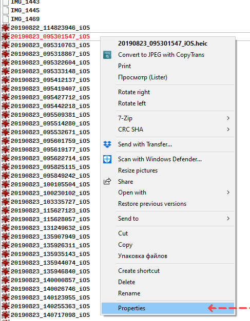
- Right-click on the photo file, and open the context menu.
- Go to Properties.
- Open the Details tab.
- Find the Longitude and Latitude settings in the GPS section.
Viewing EXIF data on iPhone
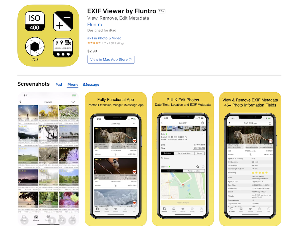
There are several apps for iOS that allow you to view or edit information from EXIF data. Let's take a look at the EXIF Viewer by Fluntro app. It is available in the AppStore and has many positive reviews.
Instructions on how to remove GPS info from photo:
- Download the app at the link. Install it on your iOS.
- Open the app and tap the Edit EXIF button in the menu.
- Go to the Location section.
- Tap the Remove location button.
- Overwrite the original file or create a duplicate of the existing photo, which will no longer contain the geolocation data.
- To open another photo, go to All photos and select the desired file.
- Repeat the above steps to remove the EXIF information about the location of the photo.
The key features of the application:
- You can delete EXIF metadata, geo location from photo and save it without any quality degradation.
- Viewing data in iCloud
- Specifications of the photo shooting: shutter speed, aperture, ISO, shooting date.
- Handy built-in viewer with quick navigation and zoom features
- Support for gestures from the latest version of iOS
- Easily copy and share your photos to other apps and services.
Instructions for Mac OS
This method of getting coordinates is suitable for photos that contain EXIF data, including GPS coordinates. Otherwise, longitude and latitude will not be available, whichever option you use.
In order to extract GPS from photo:
Ctrl + click on the image file.
Open the Get info via the context menu.
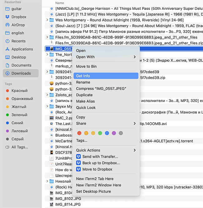
- The Details section displays the exact location when the photo was taken (Latitude / Longitude in particular).
In the case of a HEIC file, you should use a converter app in order to save JPG and open the photo on your computer.
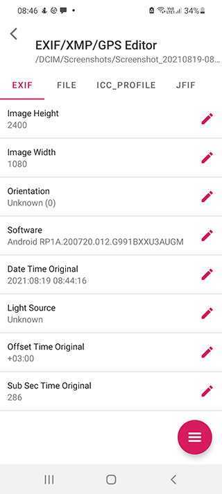
Viewing EXIF metadata for GPS data: the best apps
ExifTool
ExifTool is a mobile application for Android. It uses the same library as the aforementioned program. Using EXIF you can extract GPS coordinates saved by digital or phone camera.
IrfanView
IrfanView is a fast and handy viewer that runs on Windows. The application itself is quite powerful, but you can make it even more functional by installing an add-on package. Of course, IrfanView can read and edit EXIF Metadata both in a separate file and in batch mode.
XnViewMP
XnView is often compared with IrfanView because the range of tasks is the same. It is also worth noting the version of the program called XnViewMP. The modification is more convenient as a batch EXIF photo viewer. Therefore, we recommend using XnViewMP to work with EXIF data, in particular with geolocation.
JPEG & PNG Stripper
JPEG & PNG Stripper is a small utility with the function of clearing the confidential data "hidden" in the EXIF file. The application works on Windows and does not require installation to read location data from a file.
FAQ
Is there an online version of exiftool?
There is a service [EXIF.tools] (https://exif.tools/) that partially replicates the functions of exiftool (as the creator of the service claims). However, there is no documentation and it is not very clear which image formats are supported. It is unclear whether this site has any connection to exiftool. If you have tested EXIF.tools, write your feedback using the contact form on our site. Thank you.
Why GPS data is not always available in photos
Sometimes even when a phone is set to save location data, a photo may not have it in its current location. This can be caused by a few different actions.
The location data may have disappeared from the final file if the photo was saved multiple times. This happens when the converter does not save coordinate data or the user deliberately disabled storing additional metadata options. Saving of EXIF information is possible in Photoshop, Lightroom or any image viewer. Online services also prefer to delete confidential information in both the original copies and the thumbnails.
How to disable saving location data in photos
Coordinate data is handy not only for getting information about the place where the picture was taken, but also for organizing photos into categories. Desktop programs like Adobe Lightroom allow you to do this automatically.
Of course, you can quickly disable saving location data. This is done primarily due to security purposes; anyone can discover where and when you were at that location by looking at the properties of the photo taken with a camera. So let's figure out how to disable saving location data.
On the iPhone:
- Go to Settings > Security > Location Services > Camera
- Move the Allow Location Access slider to the Never position.
This prevents your phone's camera from accessing the GPS settings and from controlling location properties.
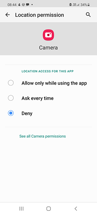
For Android 10-11 and later:
- Go to Settings > Location.
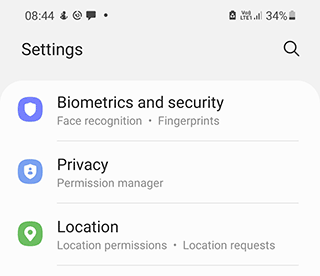
- Location > App Permissions.
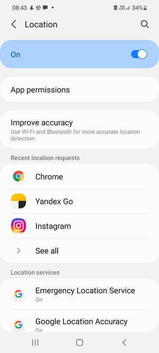
- For the Camera app, set the Location access to Deny.
Related guides
More useful articles from the GPS Coordinates, EXIF & Location Tools topic.
- Best GPS coordinates apps for Android and iPhone - 2026
Compare the best GPS coordinates apps for Android and iPhone. Find apps for latitude and longitude lookup, saving locations, sharing coordinates, and opening points on a map
About MyGpsTools Editorial Team
MyGpsTools publishes practical guides about GPS apps, maps, navigation tools, EXIF photo metadata, satellite imagery, Android Auto, Apple CarPlay, ZIP code maps, and location-based technologies. We focus on clear instructions, practical checks, official documentation, and reader feedback.