Best Apps and Services to Track States Visited in the U.S.
Discover the top services for tracking and mapping the U.S. states you've visited. These interactive tracker apps offer personalized maps, search functions, statistics gathering, and achievement systems to help users visualize their travel journey across the United States.
In this article, we've compiled the best services and apps to create a personalized states visited map and keep track of your US travel journey.
Table of contents
Travel apps and sites are indispensable for modern explorers. From facilitating navigation to finding places of interest and reviews of hotels - all this is the merit of modern services. But they're valuable not only during the trip itself. For avid travelers, it's important to visualize places they've been to, maintain travel statistics, and share their journey with friends.
Traveling across the United States often requires specialized tracker services. After all, states or unique attractions need specific visualization tools. To this end, many interactive visited states map generators and apps have been created, ranging from simple counters to full-featured tracking tools for setting travel goals and logging your experiences.
Three of the most popular states visited counter apps are 'Places Been - Travel Tracker', 'Countries Been: Visited Places', and 'Visited: Track Your Travels'.
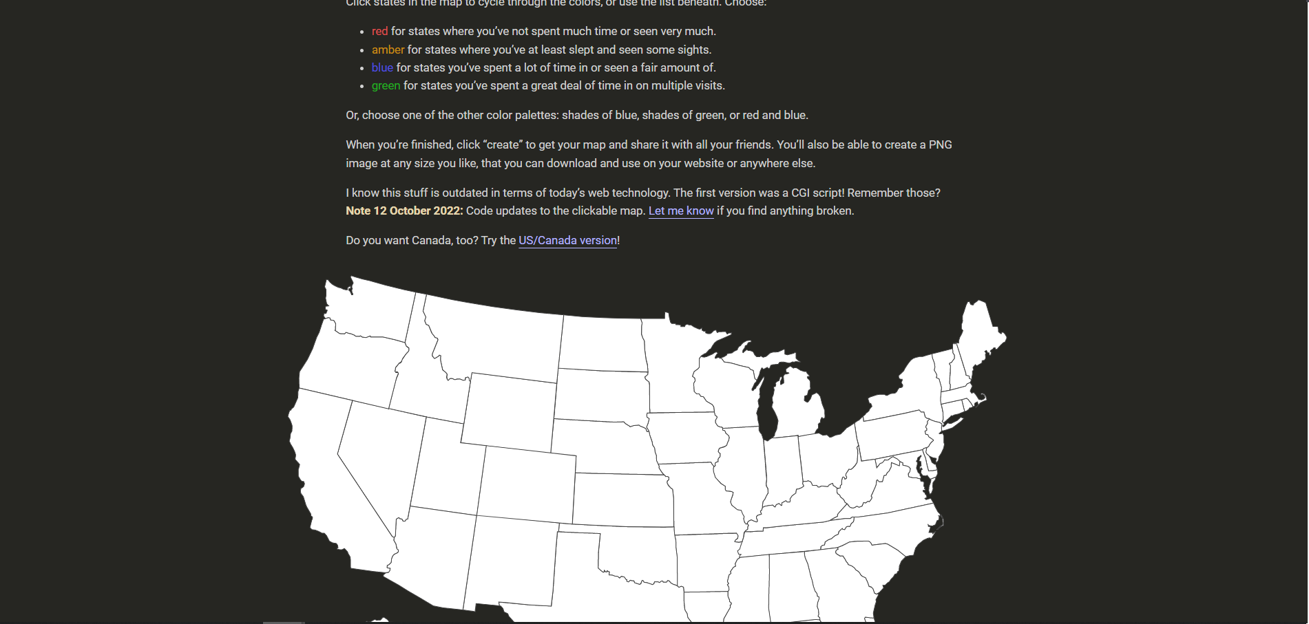
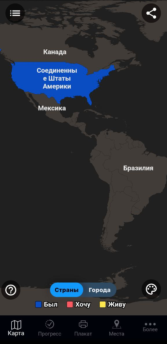
Visited States Map

This convenient minimalist site serves as an excellent states visited tracker. With no extra functions - only a focused list of visited states, it offers a clean user experience. You can mark states with both an interactive map and a table format. When hovering your cursor over the interactive US map, it displays the name of each state.
The map can be scaled, and colors and design can be customized to your preference. After creating your personalized travel record, you can download the image, share it on social networks, or place the link on your personal website.
Cons:
- The site isn't suitable for real-time tracking, as it's primarily for creating a visual "recap" of your states visited journey.
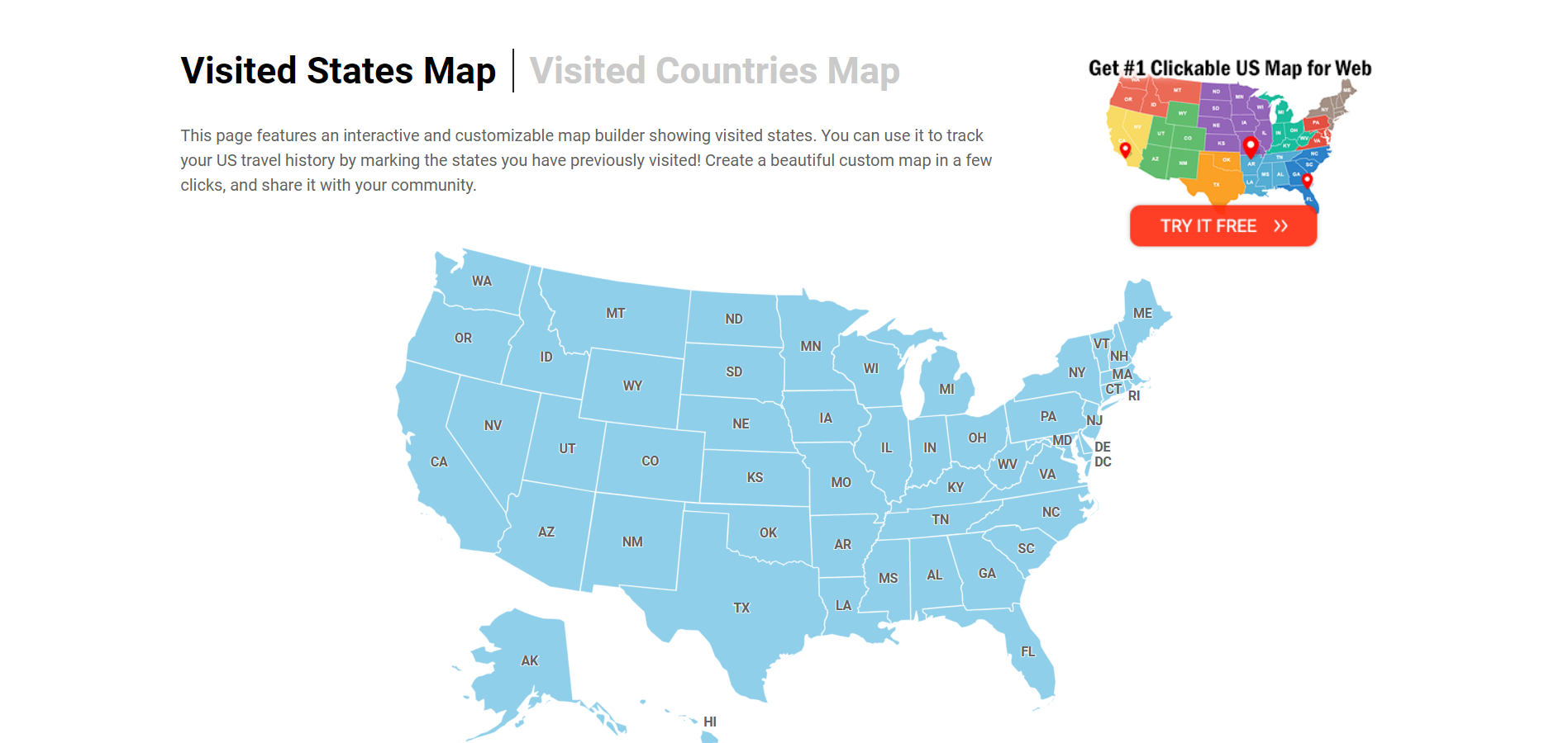
Create Your Visited States Map
Another excellent states visited map generator for visualizing your travel across United States territories and then publishing your journey. Visited states aren't just displayed on the map but are also marked with different colors for a more personalized record:
- Red - have been through or haven't spent much time;
- Orange - spent at least a night;
- Blue - spent a lot of time;
- Green - spent a lot of time sightseeing or returning several times.
U.S. states not yet visited are grayed out on the interactive map.
Colors can be customized in the palette section. You can share your state visit counter map by saving it in PNG format, sharing it on social media, or as a link.
The app is available in the Appstore for iOS users who want to track states visited on the go.
Cons:
- The service isn't ideal for real-time travel tracking.
MapLoco
A functional site for keeping track of states visited, though with a less aesthetic design than the previous options. Nevertheless, it effectively generates a map of visited states. You can mark a state by clicking on the interactive US map or using the buttons above it. The name of the state appears when you hover your cursor over the map.
You can share your created travel map on social networks or embed it on your website. The MapLoco service works not only with U.S. states but also with countries in Europe, Asia, and many other regions.
Visited States Map
A minimalistic approach to track states and countries visited with a clean interface. It features a pleasant blue and white palette that can be adjusted in the settings. One helpful feature is that abbreviated state names are marked directly on the interactive map, facilitating easier orientation. When pointing your mouse, you'll see the full state name displayed.
You can also conveniently check off places you've visited using the checkboxes in the list below the map.
Pros:
- The finished map is readily available for downloading or posting on your site, making it easy to share your travel achievements.
USA Tracker
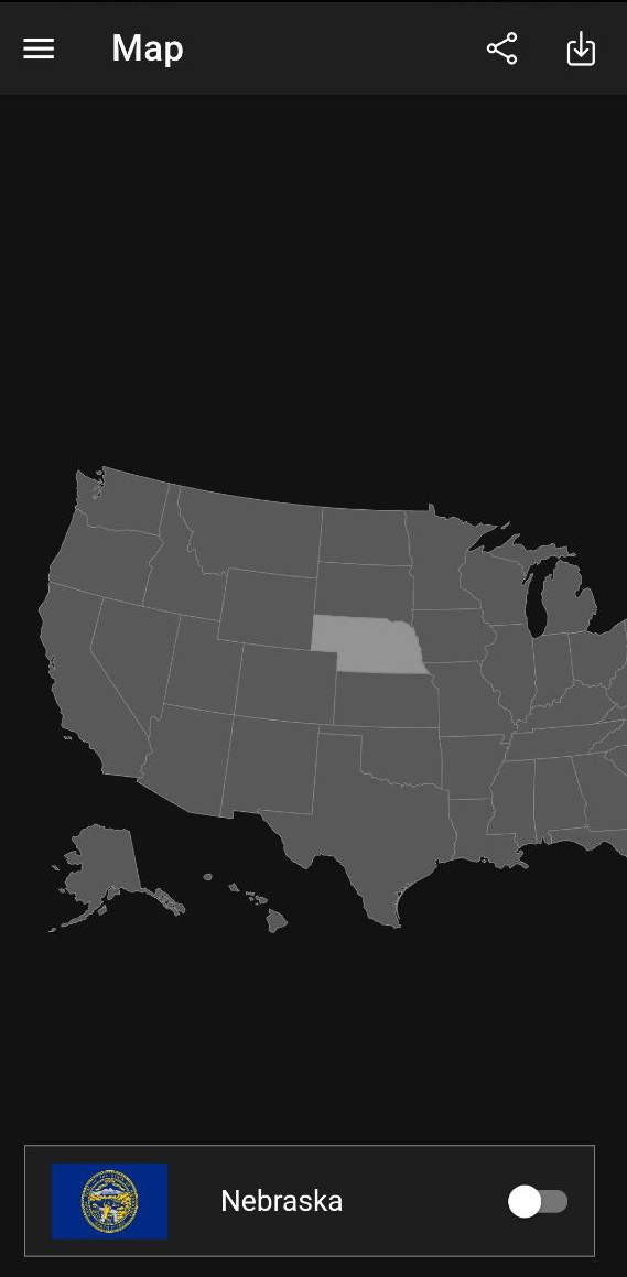
This mobile application serves as a comprehensive states visited app for Android users. Upon launching, an interactive map of the USA appears, and clicking on it reveals the name of the state and its flag. States are marked with a simple click on the button.
In the upper left menu, you'll find the "cities" section. The map displays all cities in the United States, viewable in more detail through zoom functionality. When clicking, you'll see the city name and its corresponding state. Cities can also be marked as visited in your travel log.
If marking states through the map seems inconvenient, you can use the "lists" section to track through a table format. However, cities are only available through the map interface - they don't appear in the table view.
The app maintains detailed statistics on how many U.S. territories you've explored and what percentage of the country you've discovered. It also features an achievement system with goals like "visit Alaska" to gamify your travel journey.
In settings, you can choose between light or dark theme for comfortable viewing.
Places Been - Travel Tracker
This Android states visited counter app boasts more than 100 thousand downloads. Compared to previous services, its functionality is considerably more extensive.
The app isn't limited to tracking travels across U.S. states but extends to countries worldwide, offering a comprehensive travel visualization tool.
Upon launching, it opens a world map displaying landmarks, cities, tourist areas, and other points of interest.
The city sections include a convenient search button. Visit markers appear in different colors to distinguish various types of visits or experiences.
On the home page, you can select lists of cities, airports, states, UNESCO attractions, and more to display. The app also maintains statistics for top attractions based on user reviews, helping you plan future travels.
Countries Been: Visited Places
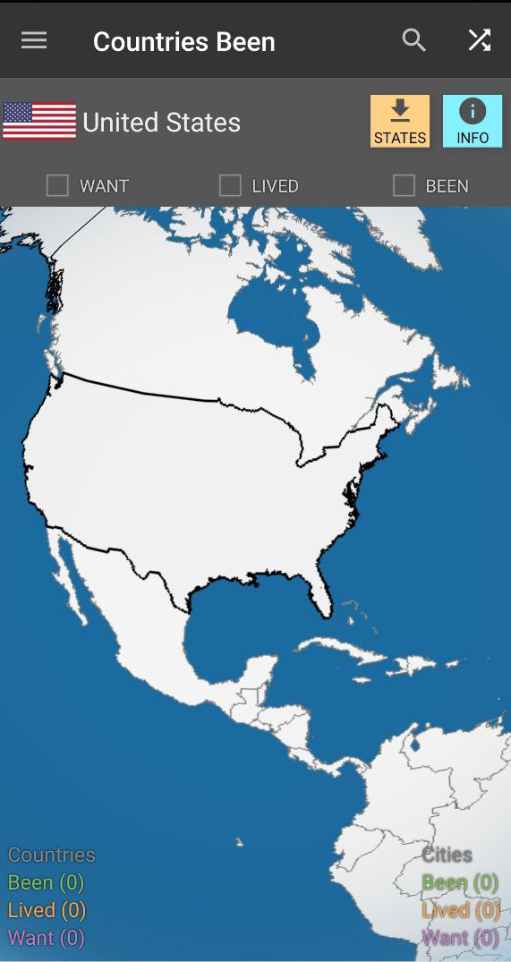
When first launching this states visited tracker app, you'll be prompted to create an account or sign in through third-party services. While not mandatory, doing so is recommended to prevent data loss.
The main page features a 3D model of Earth that you can rotate and zoom. Country names don't automatically appear when zooming, but you can access information using the button in the upper right corner, including details about capitals, population, and more.
The app collects comprehensive statistics on places you've visited, both countries and cities. You can download additional information about visited countries directly within the application.
If you're specifically tracking United States visits, it's recommended to download state locations separately. A helpful pop-up bar guides you through this process.
Visited: Track Your Travels
To use this interactive visited states map app, registration via email is required, along with opting into information emails. After that, you'll select your country and city of residence, as well as previously visited countries.
You'll then be redirected to the interactive states traveled map. Countries are displayed in the following color-coded system:
- Yellow - country of residence;
- Red - country you want to visit;
- Blue - country you have already visited.
It's worth noting that this app doesn't track individual states separately; it focuses on countries or cities. However, city tracking is only available with a paid subscription.
The app also includes goal-setting features that you can accomplish by visiting countries from your "want to visit" list. At the bottom, you'll find statistics showing the most visited places from your country and the percentage of countries worldwide that you've explored.
Related guides
More useful articles from the Travel Maps & Visited Places topic.
- Top Countries Visited App: Track Your Travel on Interactive Maps
Compare the best apps to track countries visited, create a visited countries map, count places, and organize travel history on iPhone and Android.
- GPS Apps for Student Travel: Practical Tools for Study Abroad and Field Research
A practical guide to GPS tools for students — covering offline navigation for study abroad, geotagging for field research, safety features, and apps that work without reliable data connections.
About MyGpsTools Editorial Team
MyGpsTools publishes practical guides about GPS apps, maps, navigation tools, EXIF photo metadata, satellite imagery, Android Auto, Apple CarPlay, ZIP code maps, and location-based technologies. We focus on clear instructions, practical checks, official documentation, and reader feedback.