Kentucky Map with Cities, Counties and Highways
Explore maps of Kentucky with cities, counties, highways, interstates, and a blank outline map. Use these reference maps for travel planning, school projects, and quick geographic orientation.
Map of Kentucky with selected cities, county context, and state overview. Map data: MapTiler, OpenStreetMap contributors, and Natural Earth.
Table of contents
This Kentucky map guide is designed for quick reference. It brings together the main map types people usually need: Kentucky with cities, Kentucky with counties, Kentucky highways and interstates, and a simple blank outline map for printing or classroom use.
If you only need one map, use the Kentucky map with cities and counties. It gives enough detail to locate the main cities, understand the state layout, and compare eastern, central, western, and northern Kentucky. If you are planning a route, use the road map of Kentucky. If you are studying local government, genealogy, school geography, or county seats, use the Kentucky county map.
Kentucky map images
| Map | Best for |
|---|---|
| Kentucky map with cities and counties | General reference, city and county orientation |
| Kentucky cities and towns map | Finding city and town locations |
| Road map of Kentucky | Interstates, highways, and route planning |
| Kentucky county map | County boundaries and administrative geography |
| Blank Kentucky outline map | Printing, worksheets, labeling, and classroom use |
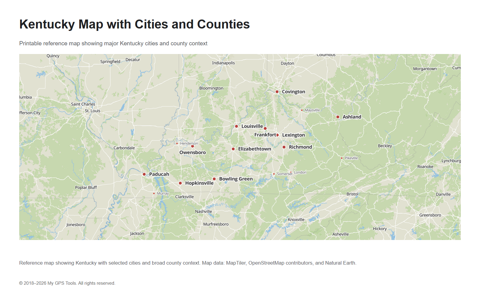
Kentucky map with cities and counties
Reference map of Kentucky with major cities and county context. Use it as the main overview map for the state.
A Kentucky map with cities and counties is the best all-purpose option for most users. It shows the state outline, the main population centers, and the county context needed for quick orientation. This type of map is useful for travel planning, school projects, local research, and general geographic reference.
The most important cities to look for on a Kentucky map are Louisville, Lexington, Bowling Green, Owensboro, Covington, Frankfort, Richmond, Hopkinsville, Elizabethtown, Paducah, and Ashland. Louisville is the largest city, Lexington is the major city in the Bluegrass region, and Frankfort is the state capital.
This map is also useful when you need to understand how Kentucky’s cities relate to its county structure. For example, Louisville is in Jefferson County, Lexington is in Fayette County, Bowling Green is in Warren County, Owensboro is in Daviess County, and Frankfort is in Franklin County.
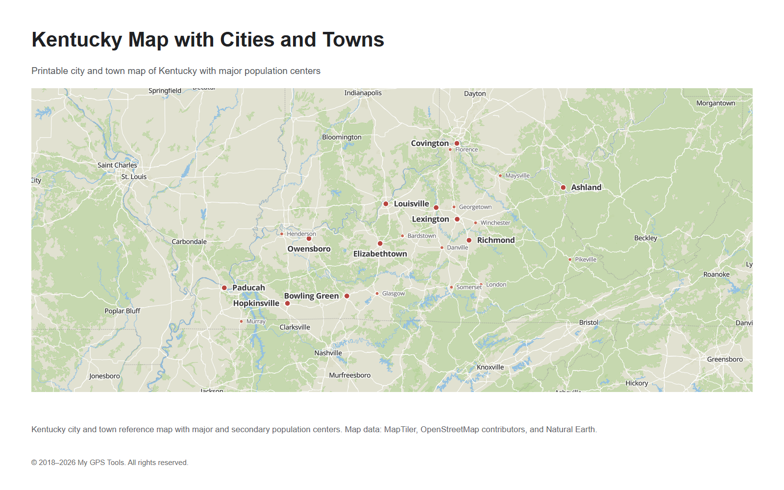
Kentucky map with cities and towns
Map of Kentucky with major cities and secondary towns for city-location searches.
Use the Kentucky cities and towns map when your main goal is to find populated places rather than county boundaries. This map should give more visual weight to city labels, with larger labels for major cities and smaller labels for secondary towns.
Major city labels should include Louisville, Lexington, Bowling Green, Owensboro, Covington, Frankfort, Richmond, Hopkinsville, Elizabethtown, Paducah, and Ashland. A more detailed version can also include Henderson, Somerset, Murray, Maysville, London, Pikeville, Danville, Winchester, Bardstown, Glasgow, Georgetown, and Florence.
This map is the most natural fit for searches such as map of Kentucky with cities, Kentucky map with cities, KY map with cities, and Kentucky map with cities and towns.
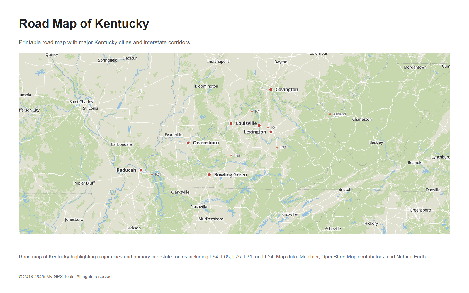
Road map of Kentucky
Road map of Kentucky showing major city references and interstate corridors, including I-64, I-65, I-75, I-71, and I-24.
The road map of Kentucky focuses on major travel corridors instead of administrative detail. It is the better choice when you need to understand how cities are connected by interstate highways and primary roads.
The most important routes on a Kentucky road map are:
- I-64, the major east-west corridor through Louisville, Frankfort, Lexington, and eastern Kentucky.
- I-65, the north-south route connecting Louisville, Elizabethtown, and Bowling Green.
- I-75, the major north-south corridor through northern Kentucky, Lexington, Richmond, and southeastern Kentucky.
- I-71, the route between Louisville and northern Kentucky.
- I-24, the interstate corridor in western Kentucky near Paducah.
For most users, a useful road map does not need every local road. It should highlight the main corridors clearly and keep labels readable.
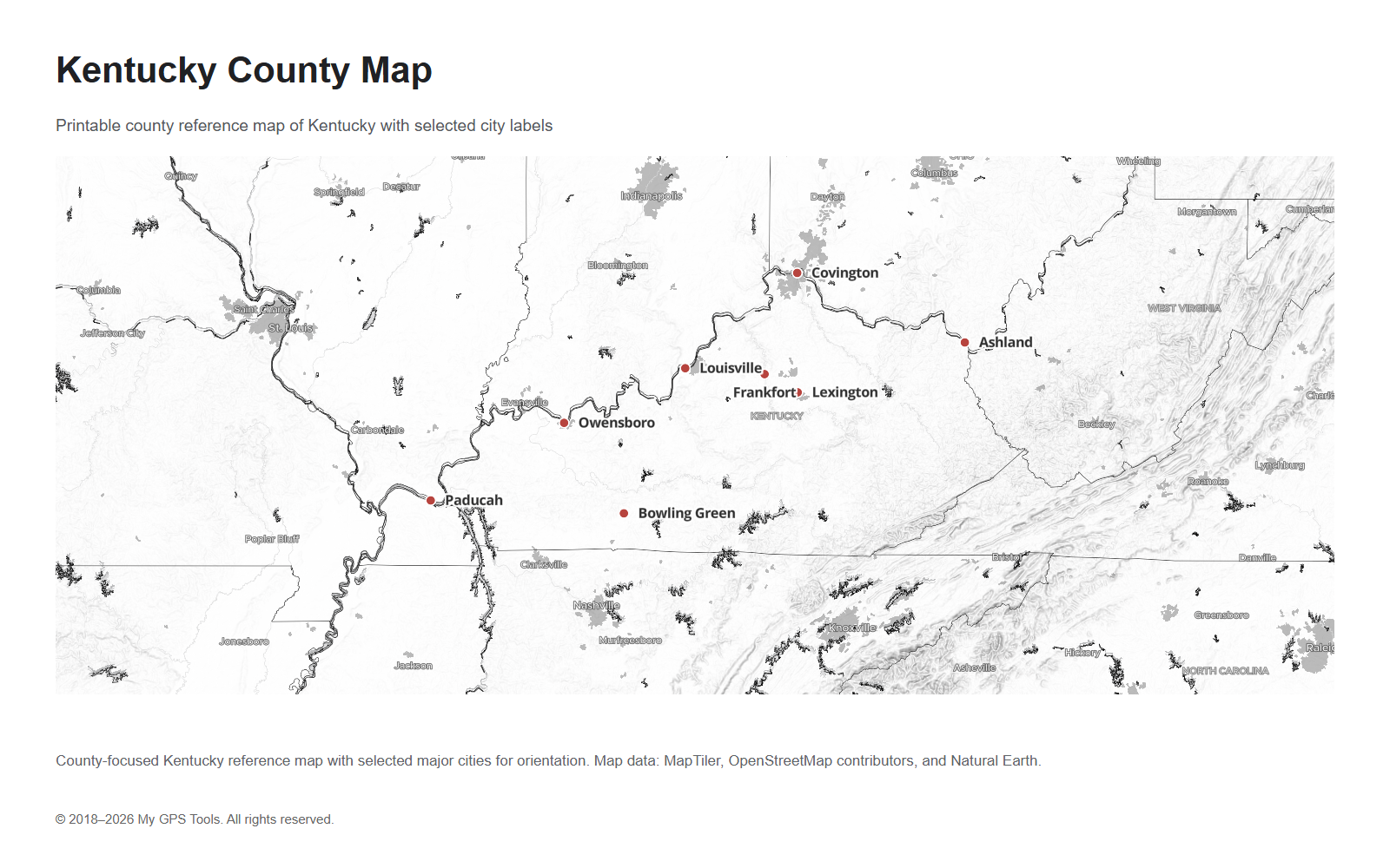
Kentucky county map
County-focused Kentucky map with selected city labels for orientation.
Kentucky has 120 counties, so a county map can become crowded if every county label is shown at a small image size. For web use, the clearest version usually shows county boundaries and selected city labels. A larger printable version can include more county labels if the text remains readable.
A county map is useful for:
- understanding local government boundaries;
- checking where a city sits within the county system;
- school geography assignments;
- election and district context;
- genealogy and historical research;
- travel planning by county.
Important counties to recognize include Jefferson County, Fayette County, Warren County, Daviess County, Boone County, Kenton County, Campbell County, Franklin County, McCracken County, and Boyd County. These counties contain or border many of Kentucky’s most searched cities and metro areas.
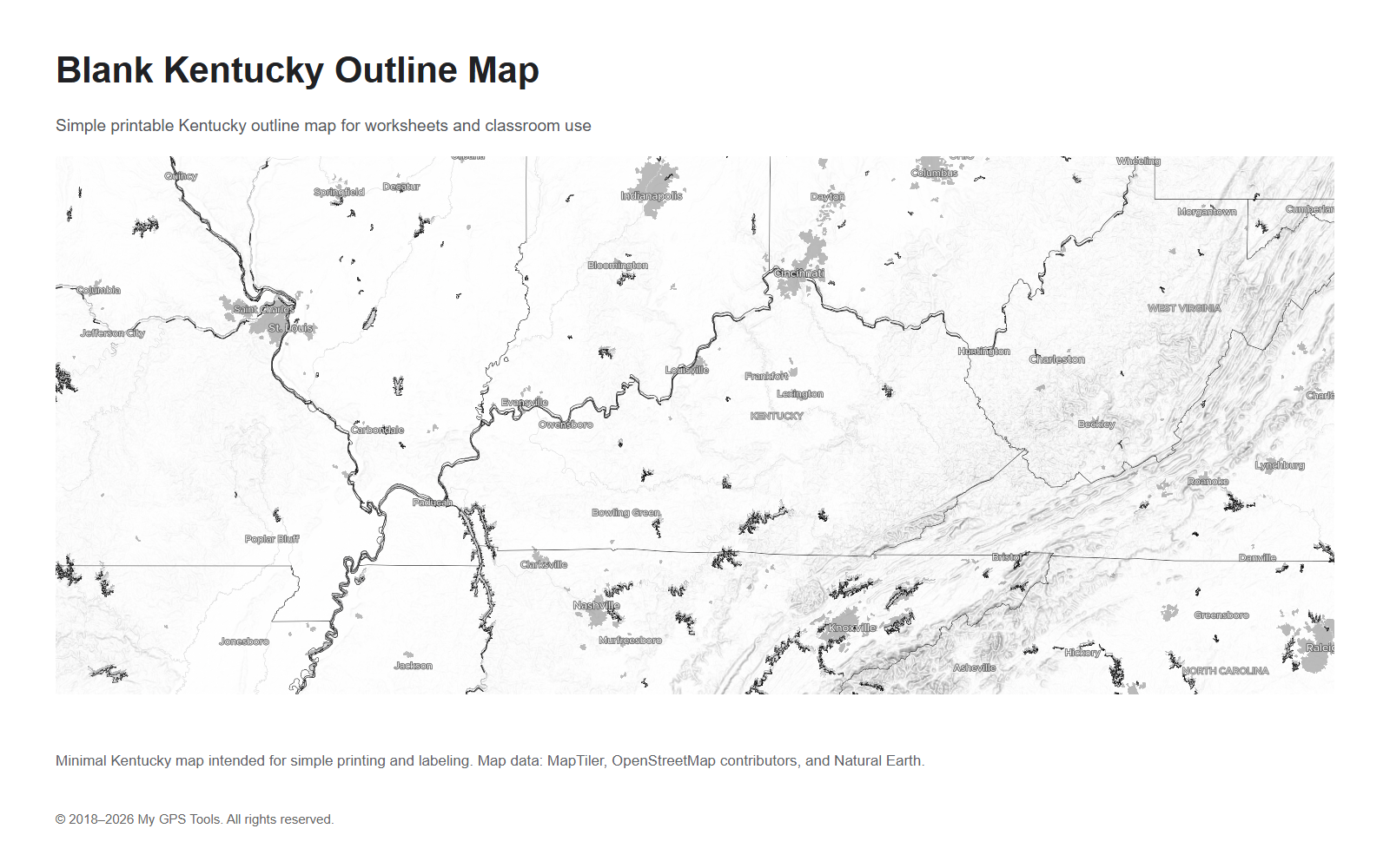
Blank Kentucky outline map
Minimal Kentucky outline map for printing, worksheets, and classroom labeling.
A blank Kentucky outline map is useful when you do not want a detailed reference map. It can be used for worksheets, labeling exercises, presentations, classroom activities, and simple geographic orientation.
A clean blank map should usually include the state outline and, optionally, county boundaries. It should avoid heavy colors, dense road labels, and unnecessary visual decoration. If the map is intended for school use, a black-and-white version is often easier to print and mark by hand.
Main cities on the Kentucky map
Louisville is the largest city in Kentucky and one of the main reference points on the state map. It sits along the Ohio River in north-central Kentucky.
Lexington is the major city in the Bluegrass region and is one of the most important urban centers in central Kentucky.
Bowling Green is an important city in south-central Kentucky and a useful reference point for the I-65 corridor.
Owensboro is located in western Kentucky along the Ohio River.
Covington and nearby northern Kentucky cities sit across the river from Cincinnati, Ohio.
Frankfort is the state capital and is located between Louisville and Lexington.
Paducah, Ashland, Richmond, Hopkinsville, Elizabethtown, Henderson, and Somerset are also important reference points on a map of Kentucky with cities and towns.
Kentucky counties and regions
Kentucky can be understood through several broad regions:
- Western Kentucky — includes Paducah, Murray, Hopkinsville, Owensboro, and the western river counties.
- South-central Kentucky — includes Bowling Green, Glasgow, Somerset, and communities along the I-65 and Cumberland Parkway corridors.
- Central Kentucky / Bluegrass region — includes Lexington, Frankfort, Georgetown, Richmond, and nearby counties.
- Northern Kentucky — includes Covington, Florence, and counties near Cincinnati.
- Eastern Kentucky / Appalachian Kentucky — includes Ashland, Pikeville, London, and mountain communities.
For a general reference map, these regional labels are often more useful than adding too many small roads. They help users understand the state quickly without turning the map into a dense road atlas.
Main highways and interstates in Kentucky
Kentucky’s road network is easiest to understand through a few major interstate corridors.
I-64 crosses the state from west to east and connects Louisville, Frankfort, Lexington, and eastern Kentucky.
I-65 runs north to south through Louisville, Elizabethtown, and Bowling Green.
I-75 is a major north-south route through northern Kentucky, Lexington, Richmond, London, and southeastern Kentucky.
I-71 links Louisville with northern Kentucky.
I-24 serves western Kentucky and connects the Paducah area with Tennessee and Illinois routes.
For travel planning, use the road map of Kentucky rather than a county map. County boundaries are useful for orientation, but they do not explain route choices as clearly as a road-focused map.
How to choose the right Kentucky map
Choose the map based on the task:
| Need | Best map |
|---|---|
| Find major cities quickly | Kentucky map with cities and counties |
| Locate towns and smaller cities | Kentucky cities and towns map |
| Plan a driving route | Road map of Kentucky |
| Understand county boundaries | Kentucky county map |
| Print a simple worksheet | Blank Kentucky outline map |
| Compare regions of the state | Kentucky map with cities and counties |
For most users, the cities-and-counties map is the best starting point. It gives a balanced overview without the clutter of a full road atlas.
FAQ
What is the best Kentucky map to use?
For general reference, use a Kentucky map with cities and counties. It shows the main cities and the county context without becoming too detailed.
What is the capital of Kentucky?
The capital of Kentucky is Frankfort. It is located between Louisville and Lexington.
How many counties are in Kentucky?
Kentucky has 120 counties. A county map is the best option if you need to study county boundaries or locate a city by county.
What are the main cities on the Kentucky map?
The main cities include Louisville, Lexington, Bowling Green, Owensboro, Covington, Frankfort, Richmond, Hopkinsville, Elizabethtown, Paducah, and Ashland.
What are the main interstate highways in Kentucky?
The main interstate highways include I-64, I-65, I-75, I-71, and I-24. These routes connect Kentucky’s largest cities and regional corridors.
What is the difference between a Kentucky county map and a road map?
A Kentucky county map focuses on county boundaries and administrative geography. A road map focuses on highways, interstates, and driving routes.
Can I use a blank Kentucky map for school?
Yes. A blank Kentucky outline map is useful for school projects, worksheets, labeling activities, and presentations. A simple black-and-white version is usually easiest to print.
Which Kentucky map is best for travel planning?
Use the road map of Kentucky for travel planning. It shows the main highway corridors and helps you understand how cities are connected.
Related guides
More useful articles from the Map Tools & Printable Maps topic.
- Athlone Town Map
Download the official Athlone map and explore attractions, landmarks, and walking routes. Discover the best things to do in Athlone, Ireland's hidden gem
- Ballina Town Map
Download the official Ballina map and explore attractions, landmarks, and walking routes. Discover the best things to do in Ballina, Ireland's hidden gem.
- Map of Ireland with Cities and Counties — Printable
Find printable maps of Ireland with cities, counties, towns, roads, tourist regions, and full-size PNG map downloads for travel planning, classroom use, and quick reference.
- Arkansas Map with Cities, Counties and Roads
Explore Arkansas maps with cities, towns, counties, highways, regions, and a blank outline map. Use these printable-style reference maps for travel planning, school projects, county research, and quick geographic orientation.
- Map of Iowa with Cities, Counties and Roads
Explore maps of Iowa with cities, counties, major roads, interstates, and a blank outline map. Use these reference maps for travel planning, school projects, and quick geographic orientation.
About MyGpsTools Editorial Team
MyGpsTools publishes practical guides about GPS apps, maps, navigation tools, EXIF photo metadata, satellite imagery, Android Auto, Apple CarPlay, ZIP code maps, and location-based technologies. We focus on clear instructions, practical checks, official documentation, and reader feedback.